While this page is mostly correct, it is most definitely not current. It was written in 2001 and last seriously updated in 2006. These days the Austrians use WGS84 GPS like eveyone else.
For the nitty gritty about coordinate systems in Austria see:
Troggle report: UTM/G&K entrance data
Troggle report: entrances
GPS and coordinate systems
Basic Coordinate Systems.
Geographical fixed points on Loser
The Austrian Kataster areas
SD 10 Handbook: Vergleich der ÖK 50 mit der neuen ÖK 50-UTM
Location fixing: How to obtain a fixed point for a cave survey
From Patrick Warren (qgis3-survex-import):
"Many of the cave entrances are
recorded using a truncated form of the MGI / Gauss-Krüger (GK) Central Austria
CRS (the non-truncated form is
EPSG:31255).
This truncated CRS corresponds to a proj4 string
+proj=tmerc +lat_0=0 +lon_0=13d20 +k=1
+x_0=0 +y_0=-5200000 +ellps=bessel
+towgs84=577.326,90.129,463.919,5.137,1.474,5.297,2.4232 +units=m +no_defs
(...this should be all on one line).
This is derived from the proj4 string for
EPSG:31255
by changing the +y_0 entry.
For more details and examples of survex *cs commands see
cave_surveying_and_gis.pdf."
Local copy of cave_surveying_and_GIS.pdf (downloaded 2023-09-30).
[See Wookey's article on very early GPS shennaninghans too: GPS For Expedition cave location which records our first tangles with G&K.]
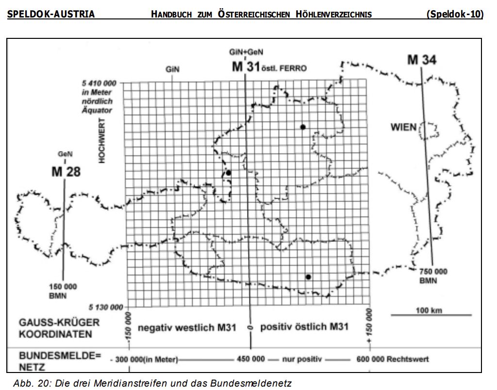
The coordinate system used by the Austrian Kataster is called the Gauß + Krüger Landeskoordinatensystem, which is supposedly identical to the widely used Universal Transverse Mercator system (Gauß analysed the projection in 1822 and Krüger published formulae to translate to/from Lat/Long in 1912). In our area, this is UTM zone 31. At least, this was our belief, but we don't seem to be getting perfect agreement between UTM/31 figures from GPS and the G&K coordinates of fixed points... This is probably because the bulk of Austria is in UTM zone 33 which you will see if you use a GPS, which will give coordinates in zone 33T. Hmmmm. [See SD 10 Handbook, paras 8.7 and 8.8: ÖK 50-UTM for a possible explanation - Ed.]
Within this system, there are a number of triangulation points surveyed purely for the purpose of locating caves: these are the Katastertriangulierungspunkte, or KT points. A point to watch when reading the Austrian literature is that the numbers labelled X and Y are the opposite way round from what seems normal to most people, ie. X is the northing and Y is the easting. The X coordinate, when quoted in full, is actually the distance in metres north of the equator, but usually the leading two digits are omitted, to give the same number of digits in the two coordinates. When the two extra digits are quoted, then the coordinates are not the same length, which can cause confusion if you're used to British National Grid references (where the east and west coordinates are run together as if a single number).
Within our area, a number of derivative points were surveyed (with a laser rangefinder/theodolite) near to various caves. This work was done in two sessions, in summer 1987 (with CUCC) and in 199x (with ArGe?). The points are marked with spits in the rock, and originally with some form of flagging tape. However, those which aren't right next to well-known caves are now proving quite hard to find in the field, at least partly owing to some very poor sketching of their locations.
For these derived points, the main number is just a sequence number. The ones which were derived via an intermediate derived point (rather than directly from KT points) have a prefix indicating the point from which they were derived. Hence, for example, point 7/9 on the 201 path near Elchhöhle, was the ninth derived point, and was found by theodoliting and rangefinding from point 7, on the Bräuning Nase. This numbering makes it easier, if one point is found to be in error, to work out which ones were derived from it and will therefore also be wrong.
As far as we are aware, all of these points which we have visited are correct, with the exception of 7/11 on the col between the SMK ridge and the Nase (not far the old Nase Top Camp), which seems to be out by an angular error of 25 or 26° from the Nase point. In the table, point 14/16 is also noted as possibly being dodgy, but we have no real indication of why.
This table shows the coordinates of the laser points in UTM using the WGS84 datum, which is the coordinate system we now use for the expo dataset (and which the Austrian's kataster also now uses). If you want the original coordinates, see the *fix commands in the file fixedpts/laser.svx in the Survex dataset.
[Just noticed in 2025: the altitudes in loser/fixedpts/laser.svx are not te same as those in the table below. Current altitudes are 46.81m lower as we now measure altitude from the geoid not the ellispoid; or possibly vice-versa.]
| Code | Easting | Northing | Altitude | Description |
|---|---|---|---|---|
| KT114-96 | 411524.92 | 5282241.69 | 1950.78 | Hinterer Schwarzmooskogel Trig point |
| 0 | 411230.25 | 5281734.79 | 1862.27 | Hilfstandpunkt (hillock N of 161) |
| 0/1 | 410927.39 | 5281274.61 | 1829.18 | Between 156 and 201. Cloth labelled "0/1" replaced with alloy tag "LASER 0/1" (1999) |
| 0/2 | 410865.82 | 5281370.64 | 1796.89 | Near 0/1 |
| 0/3 | 410702.33 | 5281366.04 | 1756.99 | Near 0/2 |
| 0/4 | 410765.94 | 5281478.20 | 1734.28 | Wolfhöhle |
| 0/5 | 410849.40 | 5281721.63 | 1737.52 | up gully and left from 107 tatty cloth replaced with alloy tag "LASER 0/5" 1998 |
| 0/6 | 410720.07 | 5281885.87 | 1694.60 | Near 76 - between the three entrances. Very faded blue cloth replaced with alloy tag "LASER 0/6" in 2006 |
| 0/7 | 410251.61 | 5281188.86 | 1816.60 | Bräuning Nase |
| 7/8 | 410857.13 | 5280461.49 | 1779.22 | Felskuppe im Bereich des Vd. Schwarzmooskogel (Weiße Warze, The Nipple, Bunter's Bulge) |
| 7/9 | 410201.88 | 5279997.48 | 1635.15 | Elchhöhle 1623/31. Punkt am Weg (point in the path) |
| 7/10 | 410445.91 | 5280892.78 | 1676.80 | Kratzer Valley below the col |
| 7/11 | 410494.46 | 5281341.02 | 1729.50 | Schwarzmoossattel (the col) - we believe this is in error |
| 8/12 | 410744.26 | 5280640.97 | 1771.87 | |
| 8/13 | 410997.27 | 5280882.83 | 1821.97 | |
| 8/14 | 411278.13 | 5280630.13 | 1736.31 | Schwarzmooskogeleishöhle 1623/40a |
| 14/15 | 411285.73 | 5280680.75 | 1733.49 | |
| 14/16 | 411374.72 | 5280464.78 | 1707.22 | (possibly dodgy ?) |
In some Austrian literature, the easting quoted is in a system labelled BMN. The Easting grid line +36000 (Gauß + Krüger, M31) is the same as BMN 486000, and translation appears to be a matter of simple addition or subtraction, though it may prove to be more complex than this over a large enough area, as already indicated by GPS work...