Surveys and Rigging Guides
There is a particularly inadequate elevation which was published in Cambridge Underground 1985.
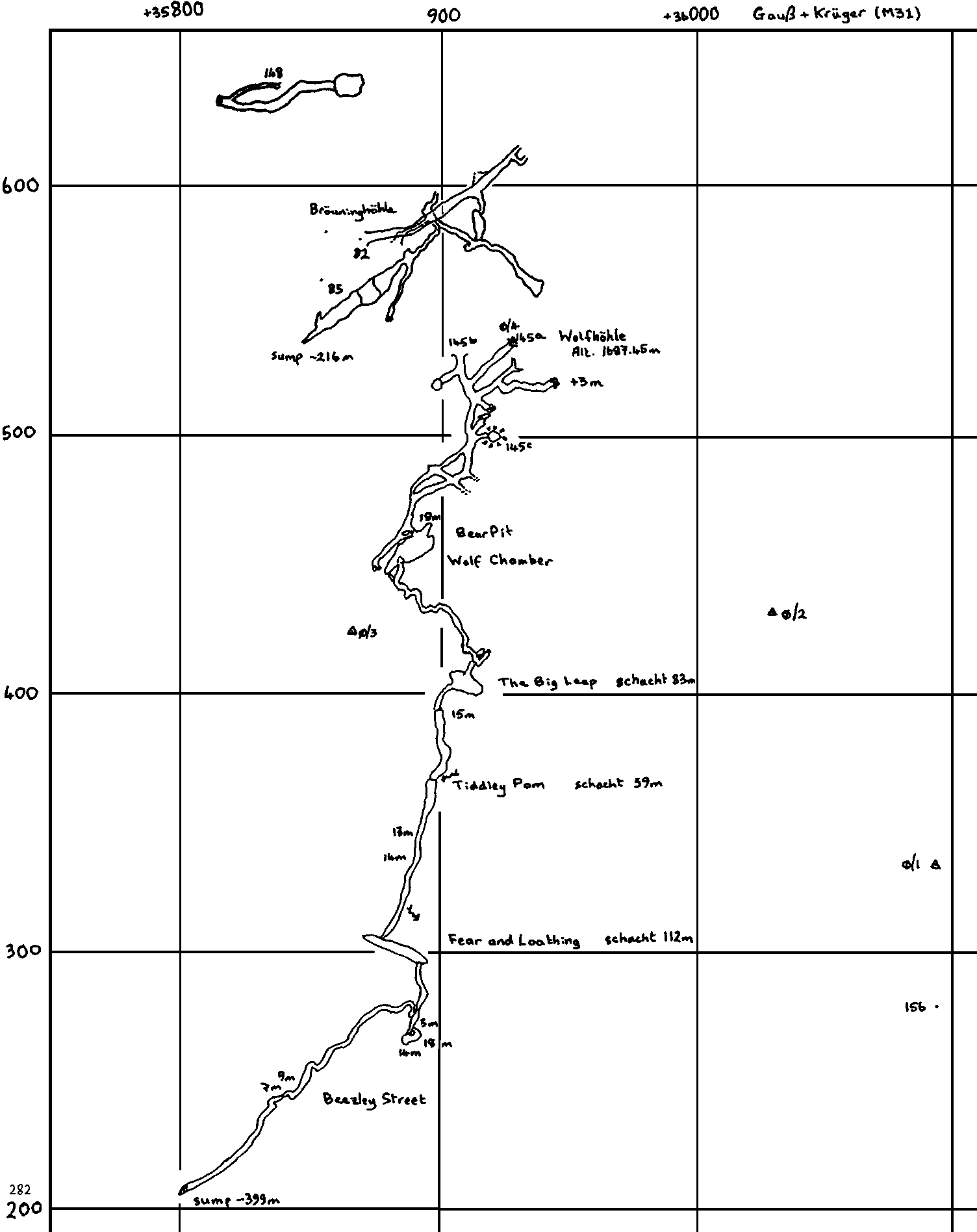
There is an area plan, drawn at 1:2000, showing 145, 82 and 148 on Gauß and Krüger coordinates, which has never been published.
There is enough survey bumph to draw a respectable plan.
Underground Description
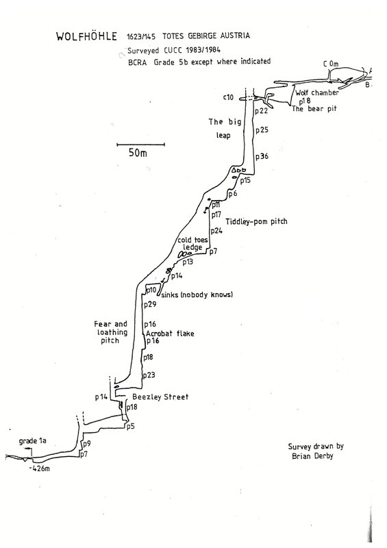
Entrance is 2m high and 1m wide and walking passage leads for 120m of level going to first pitch, with a few side passages (one to higher entrance). Pitch is 19m into Wolf Chamber where the skeleton proved not to be of a wolf but of a Brown Bear, Ursus arctos. A pit in the floor, the Bear Pit is blind, and the continuation of the entrance pitch emits no draught and is believed to choke, but was never seriously investigated. A loose 3m climb at the far end of the chamber leads up into a draughting tube. This leads to an awkward 15m slimy tube descent, Bog Seat Climb, best laddered. A short grovel enlarges to a sandy stooping passage which pops out over the edge of a large black hole. Off to the left at this point a crawl intersects a larger passage leading to another set of smaller shafts only partially descended. It is also possible to reach the opposite side of the big pitch by this route.
The 83m Big Leap is rigged in three sections of 22, 25 and 36m via two freehanging rebelays and a deviation near the bottom, in a large rift with black peaty mud on the walls in the upper section. The rift narrows and bottoms out in a small streamway blocked here and there by jammed boulders which no longer (since 1984) constitute a squeeze. Short traverses and pitches of 15m and 6m are straightforward until a second large shaft is reached. The water cannot be avoided on the 59m Tiddley Pom pitch, which can become a serious proposition in wet weather. The first section is 11m, to the level where a heavy drip (rapidly becoming a torrent in thunderstorms) enters. The rebelay bolt is tucked away to the left, a long reach round the corner. Further sections of 17 and 24m in a circular shaft of about 6m diameter reach a big wet ledge. The final section of 7m reaches a big dry stance on jammed boulders, Cold Toes Ledge. This is far enough out of the water to be an acceptable place to sit and wait for 16 hours, or to brew soup.
The stream continues to drop in a rift, with pitches of 13 and 14m from jammed boulders. The water then sinks into a slit, Nobody Knows, which was descended for 15m before becoming too tight. To continue, traverse over this hole and continue a short way to a large black chasm, the 112m Fear and Loathing Pitch, involving some airy traversing near the top. Sections of 10, 29 and 16m reach Acrobat Flake, where careful rigging is required to avoid a particularly gymnastic changeover for the next section of 16m. The rift (never wider than 3-4m) continues with drops of 18 and 23m to land on an unpleasant bit of damp floor: Las Vegas.
A particularly unpleasant mud-walled rift, Beezley Street, ("where the rats have rickets") continues as a traverse if you can stay up, or a nasty thrutch otherwise. This ends abruptly where an aven brings clean washed limestone for the next 14m pitch. A clean, but sharp traverse continues to corkscrewing 18 and 5m pitches into The Drainage Ditch, a wading depth section of passage occasionally blocked by boulders, which hold back the static pools. Short pitches of 8, 9 and 7m twist down to another section of drainage ditch which continues for a few more metres to a static sump 399m below the main entrance.
A hole above the sump leads to a small, muddy, grovelly continuation to some small avens and a further sump, before closing down.
Geology : Tubes near the entrance are formed along the prominent NE-SW joint direction in the area, which so dominates the nearby Bräuninghöhle, and the cave trends generally SW as it drops. However, all the major vertical development is in deep shafts on joints at right-angles to this major trend, on a strike of about 120-300°. Fear and Loathing pitch in particular is in a strikingly narrow rift over 110m deep, suggesting an almost vertical joint. Below this shaft there is very little significant jointing, and the cave meanders considerably before the dismal end another 140m SW.
Explorers
CUCC 1983-4.References
There are a lot more sketches and draft surveys online, but are not properly indexed because this was all before we had a proper wallets system. e.g. see 1983#01 and 1983#03.Wallets: scanned survey notes
There are 2 wallets with data for this cave:2005#22 2005#23