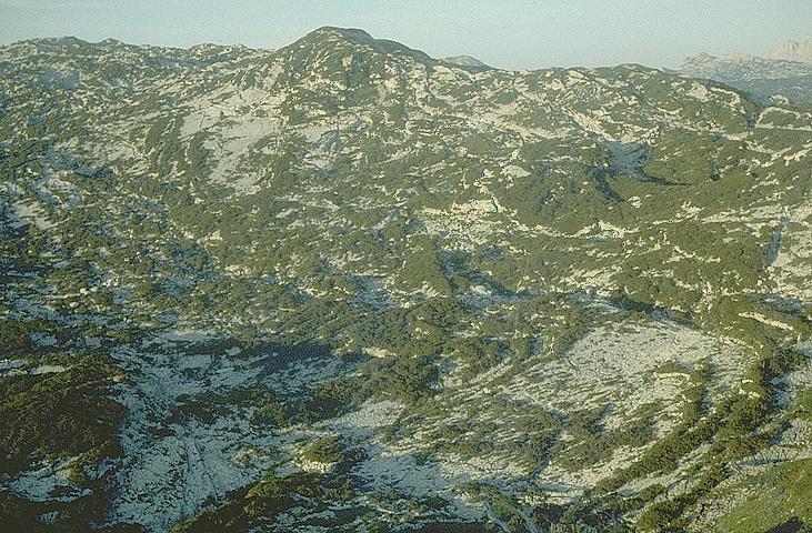
View of the nearer plateau from the Bräuning Nase
View of the nearer plateau from the Bräuning Nase
Photo © Andy Waddington, 1978
The Hinter Schwarzmooskogel is the peak in the centre of the view,
the Steinbrückhöhle Top Camp location is at the top left, but this photo was taken
24 years before we established ourselves there in 2002.

Click on the thumbnail to see an enlargement of this photo (in b&w) centrered on the current top camp:
This photo was taken from the steep north slopes of the Bräuning Nase which can be climbed via a shallow gully. At the north end of the Bräuning Nase short ridge, by hacking through dwarf pine, Laser Point 0/7 can be found, in an entertaining position perched over the cliff down to the Schwarzmoossättel. The actual summit is at the south end of the ridge, and views of the plateau from anywhere on the top are restricted by the clinging pines. This view is from the ridge leading west from the Nase towards the higher points of the Bräuning wall. Compare this 1978 shot with the more recent (1996) view from the Bräuning Nase to see how vegetation has changed since CUCC started to visit the area.
This shot was taken ten years before we first camped on the plateau just over the col in 1988. Old (Schwarzmoossättel)Top Camp would eventually be sited just off the bottom of the picture left of centre. Behind this, an area of limestone karren with noticeable diagonal scarps is the location of 1623/171 whilst to the right and nearer is another patch of bare karren containing 198 (B11), 164 and 189. Hinterer Schwarzmooskogel is the peak on the skyline left of centre, and Kaninchenhöhle's top entrance lies just in from the right hand edge of the picture on the horizon.