The far plateau
The far plateau
Photo © Andy Waddington, 1996
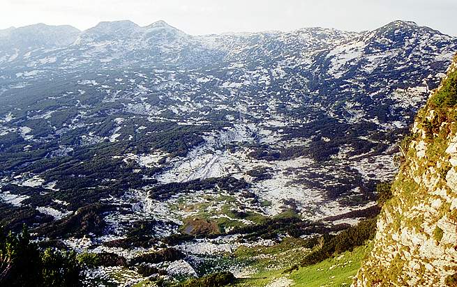
This view of the far plateau from the Bräuning Nase shows the Hinter Schwartzmooskögl on the skyline to the right, and from the left: the Grösser Wildkögl (looking like a ridge), the Kleine Wildkögl (with a flat top) and the Greiskögl (the pointy one). The Augst-Eck is the imperceptibly low rise in the middle, on which we have had our Top Camp since 2002.
The lower site of Old Top Camp is in the brown and green area just left of lower centre. Behind this, an area of limestone karren with noticeable diagonal scarps is the location of 1623/171 whilst to the right and nearer is another patch of bare karren containing 198 (B11), 164 and 189. Hinterer Schwarzmooskogel is the peak on the skyline on the right, and Kaninchenhöhle's top entrance lies some way off the right hand edge of the picture on the horizon.
Above Old Top camp just beyond the col, the steep slopes of the Bräuning Nase can be climbed via a shallow gully. At the north end of its short ridge, by hacking through dwarf pine, Laser Point 0/7 can be found, in an entertaining position perched over the cliff down to the Schwarzmoossattel. The actual summit is at the south end of the ridge, and views of the plateau from anywhere on the top are restricted by the clinging pines. This view is from the shoulder above the ascent gully, in a grassy area.