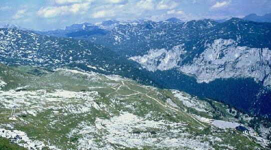
From the Loser Panoramastraße Bergrestaurant car park (bottom right of picture), take the path leading from the NE corner, which is slightly shorter, and soon joins the main path. Alternatively, follow the main touroid path, numbered 201, and marked with red and white paint at frequent intervals (heading up left of centre in the picture). Following this gently undulating path for ten to fifteen minutes leads to Egglgrube. To the left is a valley containing several obvious sinkholes, with a junction path leading to Bräuning Alm. Ahead and to the right is a 10m cliff rising from the pasture to an area of karren and dwarf pine.
Follow the main path 201 straight ahead up a break in the small cliff and continue over karren which is well covered with Lärchen (dwarf pine, spuriously known as "Bunde" within CUCC). A T-junction is met, left leading into the Kratzer valley (an area explored by the German group), while right is the main path. This junction is easy to miss on the return in mist or at night. A few minutes further on, where a cave is marked by a large red Omega in the middle of the path (1623/28), there is a junction path to the left (route to the Nipple), and Laser-fixed point 7/8 marked with a bolt.
 and beyond
The main 201 path beyond 1623/28 leads after several minutes to a strongly draughting entrance on the left numbered 32. To the left after this are routes to 41, 141 and 142 and the original approaches to 143 and 144. The main path descends steeply for a while; 115 lies downhill to the right. Ahead, 87 lies up a valley to the left, and considerably further, paint marks lead left to 109 and 113 (Sonnenstrahlhöhle). 151-155 are also up left hereabouts.
If the main path is followed considerably further, it joins the path from Altausseer See through Hochklapfsattel into a 174m deep doline, around a kilometre long, and eventually to Appel Haus and the Wildensee. Just near this junction it is possible to gain access to the Scarface (1623/161d) entrance to Kaninchenhöhle, but the route is non-obvious and much obstructed by the dwarf pine - CUCC found this approach to be too hard and instead used an approach as for 161a. Much futher on, high up to the left, on Roßkogel, is the area explored by LUSS (mainly in Kataster area 1626).