From Lackerbichl over Bräuning Kuntal towards Bräuning Alm and the Bräuning Wall.
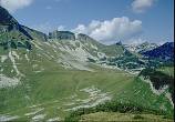
Following marked path 201 (Stögerweg) from the Bergrestaurant northwest, a signposted junction is met, below a ski-lift. Left here leads over the minor peak of Lackerbichl and on to Bräuning Alm. To the NW of this peak is the closed depression of Bräuning Kunntal, a doline deep enough to merit a ski-lift climbing out of it. Two small springs, below the rim to ENE and ESE, feed into a bog with no speleological potential.
From Lackerbichl over Bräuning Kuntal towards Bräuning Alm and the Bräuning Wall.
Bräuning Alm is more conveniently approached by continuing on the main path to a further signposted junction at Egglgrube. Ahead, the path climbs a small scar, but left, posted to Bräuning Zinken, the path traverses above a small valley to reach a group of huts serving the summer pasture of Bräuning Alm. Springs below the huts feed into sinks in the valley bottom, but these offer no significant cave.
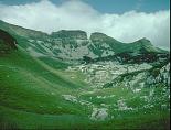
Looking up the small valley traversed by the route to Bräuning Alm
To the east of the pasture is an area of limestone scars, with another grassy area, used by CUCC for a brief top camp (camp 1) in 1977. There are a few entrances in the limestone here, and more in the valley north of the huts, leading toward the col of Bräuning Sattel. Areas of scars between this valley and the ridge used by the path to the plateau have not been looked at in any detail by CUCC, but are thought to have been prospected by the Austrians with no results.
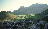
The huts of Bräuning Alm from the continuing walk up to the plateau, seen in evening light.
| Number | Name |
|---|---|
| 26 | Wasserschlinger I |
| 27 | Wasserschlinger II |
| 29 | Schwarzmoosloch |
| 30 | Grundloses Loch |
| 33 | Schichtgrenzenhöhle |
| 61 | Gemsbockhöhle |
| 95 | Bräu Schacht 95 |
| 96 | Bräu Schacht 96 |