surface - prospecting along "lookfutile.svx" route
Philip Sargent
Using Garmin eTrex Venture Cx GPS (WGS84)
"lookfutile.svx" was surveyed by Chas and Planc in 1983 following the discovery of the futility series in 1982.
This entry includes recent emails which don't otherwise have a good place to record.
[Discovered a photo on the website of Planc doing this survey.]
Much bunde going directly down from the p115x entrance. Don't do that,go back along the route to
Stoger Weg and go down gully at the tree with the small cairn on it (see 115 route 18th July 2018).
Generally failed to find lookfutile.svx waypoints (not even the last one with all the red paint). Something
odd with GPS mismatch - needs nerding to resolve.
Found ent. * (doesn't go) obvious above grassy slope. It is up a 2m climb in a cliff.
This is wpt A11 in gpslog: N 47.66629 E013.81128 alt.1407m.
This was looked at by Chas & Planc in 1983 and doesn't go:
"big phreatic entrance further east up the valley" from
the 1983 logbook entry 1983-07-27.
lookfut.svx
Many photos of this area in photo archive 2018/PhilipSargent.
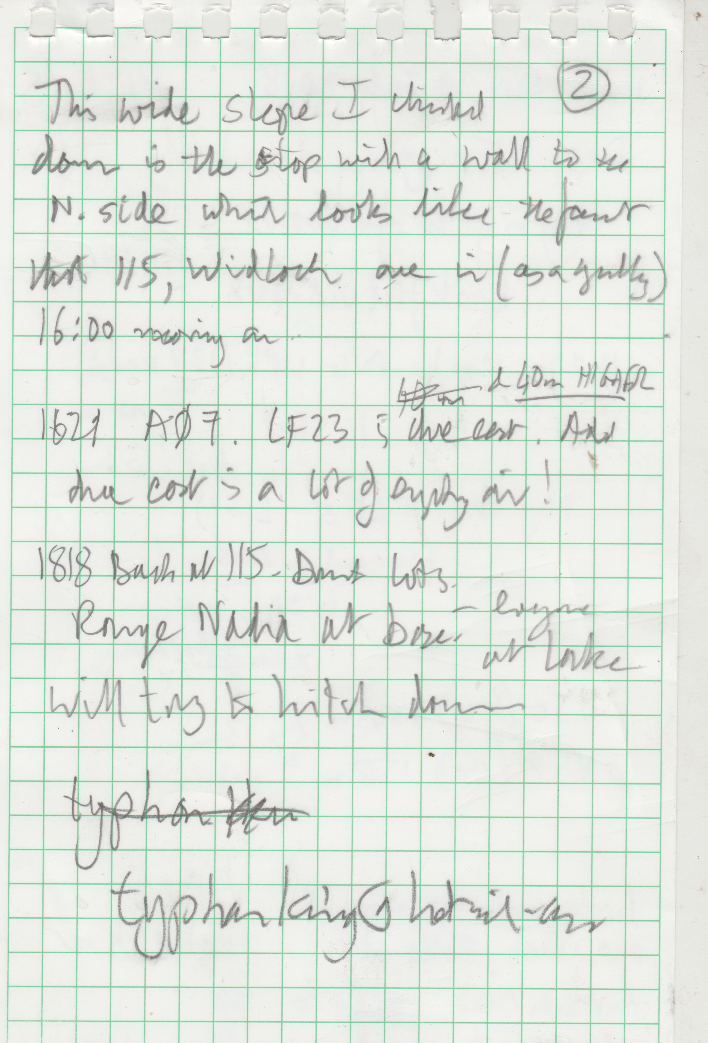
Survey station lookfutile.23 is apparently in open air due east of cliff top (which extends N-S).
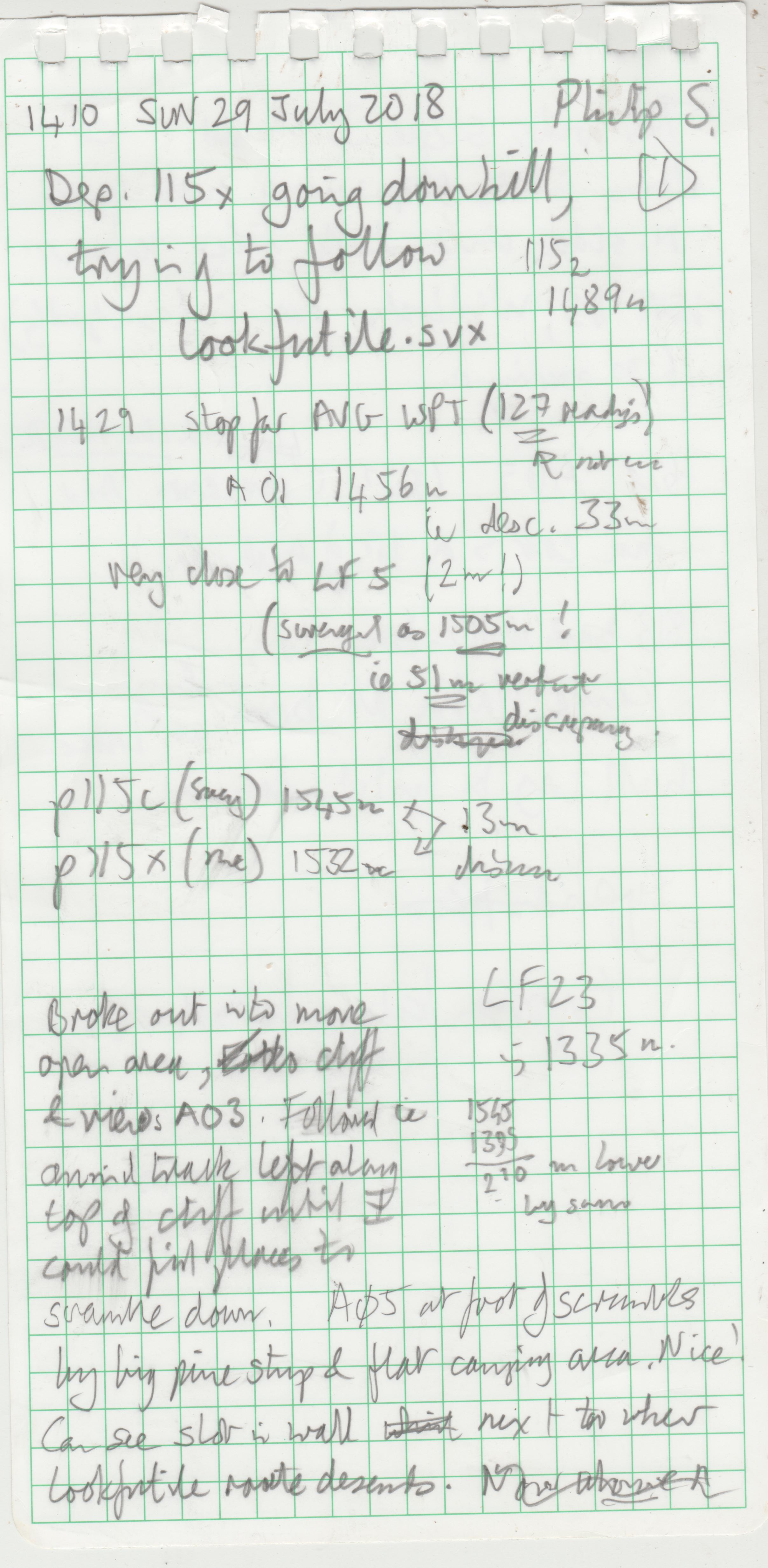
Water collection system at 115works well: decanted 3.5 litres of rainwater into bottles. About 6 litres now stashed in 115, plus a karrimat and one-man does of flapjack and another dose ofmuesli.; also large orange plastic survival bag. All other gear removed.
Walked back to Löser Hutte where I managed to catch the sunset drinking crowd and got a lift back to Staudnwirt at ~21:00. Lots of big open cliffs, no bunde, grass and camping areas.
Recent emails from very old lags on this:
On 18 July 2018 at 19:46, Charles Butcher  wrote:

    Philip

    Thank you. I’m sorry you had trouble finding it. Even the traditional route to the main entrance is quite a slog,
    and if you don’t remember it – I certainly couldn’t – you could be in for a real epic. As you probably found.
    I hope the server repairs went well.

    Thanks also for the GPS data in your previous message, and to Andy and everyone else who has worked to
    preserve this stuff. I’m astonished that we still have good records of all those muddy survey pages
    from so long ago. And to see it all connect with Google mapping is really impressive.

    Safe trip home

    Chas

On Sun, 1 Jul 2018, 10:31 Andy Waddington,  wrote:

    Sometime before sending, Philip Sargent typed (and on Sunday 2018-07-01 at 08:46:16 sent):

    > Any comments on the 115 entrances?

    I really can't remember any of this without reading the stuff on the website - but that stuff is available to
    everyone (unreliable memory is exactly why this stuff was all put there - but in the early days, which would
    cover the 115 period, we naively thought we would remember everything, that the same people would be
    going back, and that we didn't need to write everything down - though actual surveys were properly recorded).

    Where survey data was corrected for fridge north, that should be recorded in the survey notes. That was such
    a bizarre correction that I don't think it would ever have been done without explaining it. The Futility series survey
    had two compasses, Suunto 422903 and Chas' Silva 15T. Had there been a major discrepancy between them, I
    think they would have noticed. The bearings seem to be the same in the Survex dataset as in the notebook.
    ie. the first leg is 8.08 m on 320 at -11.5. That's from the dataset extracted from CVS in 2001 (which is the oldest
    I can find in a quick search here). I don't think corrections to fridge north would have been made more recently
    than that... 075 to Trisselberg cross is the same as the notes, and even if the 115 entrance wasn't located
    precisely, that ought to be enough to show if the error was more than the odd degree or two.

    Not sure if the scans of this notebook are on the site.
    Notes are a bit muddy, with no passage walls recorded.

    Did Arge not resurvey any of this ?

    Andy

Philip Sargent (Gmail)
to Charles, andrew, mary5waddington

Chas,

[and Mary, please pass on to Andy as I don’t think any email works for him these days],


Update, as promised.

Through the miracle that is survex, and the diligent curation of data* over decades by
Wadders and Wookey, I have recovered the survey points from your surface walk with Pete
on 27 July 1983 and attach as a GPX file in modern WGS84 coordinates. You can plot this
on top of a GoogleMaps photo using http://www.gpsvisualizer.com/map_input
(or select “OSM (TF Landscape)” in the drop-down on the map to see contours).

I will be re-tracing this slog and looking for more entrances in a week or so.
A bit lower than you went looks promising from the geology.

[snip]

I also attach the Futility series surveyed by us on 26 July 1983 (futility.svx)
and as resurveyed by Germans on 8th August 1999 (nutzlos.svx). But this is less
useful as GPX on Google maps as it is inside the hill of course and you would need
to use Survex/Aven itself to see it. They also seemed to have found another entrance
in 2000 which drops eventually into the phreatic stuff which they called the
Nebukad series (Nebukadnezar) and is now p115b (ent.) in the survey data.

I hope a find a cold draft coming out of rocks at least, even if I can’t dig it out.

Philip

* http://expo.survex.com/repositories/home/expo/loser/shortlog/b6c8d59090c3 is an online
look at the version control system used for cave data on Loser these days.

From: Philip Sargent (Gmail)
Sent: 21 June 2018 17:28
To: 'Charles Butcher'
Cc: andrew@pennine; 'Wookey'
Subject: RE: Aha - futility series entrance search...

Chas,

Unbelievably, that surface survey you and Pete did (“lookfutile”) is a standard part of the SMK dataset.

I can see that your final survey position was 11.7m above the drafting hole in Futility
(contrary to Andy’s notes in the file below), and 157m away horizontally. Maybe some
fridge-north corrections have been done since then.

You were also spot-on the line where the bedding plane of 115 intersects the hillside.
So going downhill from there, maintaining a heading of 118 degrees (if possible) would
track further down that bedding plane. As I remember, the survey legs may have been
ascending, but the passage roof was coming down to the sandy floor. So the draft
connection  (“Utility Entrance” ?) would be lower down.

From: Charles Butcher
Sent: 16 June 2018 23:11
To: Philip Sargent
Cc: andrew@pennine
Subject: Re: Aha - futility series entrance search...

Thanks Philip. When you told me about your plan the other day it brought back memories of
thrashing around on the hillside, but I couldn’t remember what we were looking for.

I do remember that it was harder work than being underground. I suppose a Laplander pocket saw
would be frowned on in the Naturschutzgebiet, but useful all the same.

I assume those coordinates are relative to the entrance, or to whatever else we used as a
main datum. So if you have an accurate GPS fix for that datum, wouldn't it be quite easy
to locate the hole Pete and I made? Not that that is likely to be much use, since it’s
probably the one place we know there isn’t an entrance…

Anyway, good luck and keep us posted!

Best
Chas

You wrote:
stumbled on this:
http://expo.survex.com /years/1983/log.htm

1983-07-27 | Surface survey and Prospecting below 115. | Chas, Pete
The aim was to find the end of the Futility Series popping out of the hillside below 115.
We surface surveyed down to a permanent station, marked with bolt hole and lots of red paint: P1983/1.
This was almost directly below 115 and on the edge of the big trees.
It was at E77.2, N-237.3, H -195.8, whereas the end of the Futility Series was at G30: E 139.7, N -54.2, H-187.8.
So we were (!) at the right place, but the cave end was 180m into the hillside.
We had a good look round but didn't find any signs of caves there.
So we looked at a big phreatic entrance further east (up the valley) and ~50m higher.
This was looked at in 1982, but a bit of proddling released lots of boulders + we were able to
follow up a narrowing bedding plane at ~60°, for 10m until it got too loose/small.
Very difficult descent on scree to the end of the Altausseer See + then the Schniderwirt for Weizen Bier.
Pete

and Wookey thinks some Germans had a look around there too in later years
Unfortunately we use WGS84 GPS lat./long. these days so I’m not sure I’ll be able to find this
35-year old red paint.

I’m hoping to use better geology and modern surveying to find where the bedding plane intersects
the surface this year. I’m going out for 4-5 weeks.
Philip