Wookey
The standard of CUCC surveying continues to improve as interest in the subject increases. This year we introduced instrument calibration and on-site survey computation and display, as well as continuing the process of educating the masses to the best and worst ways to survey. The calibration was in order to justify our claims of Grade 5 surveying, and the computer was both to relieve the tedium of doing the number crunching with programmable calculators and of plotting the results by hand.
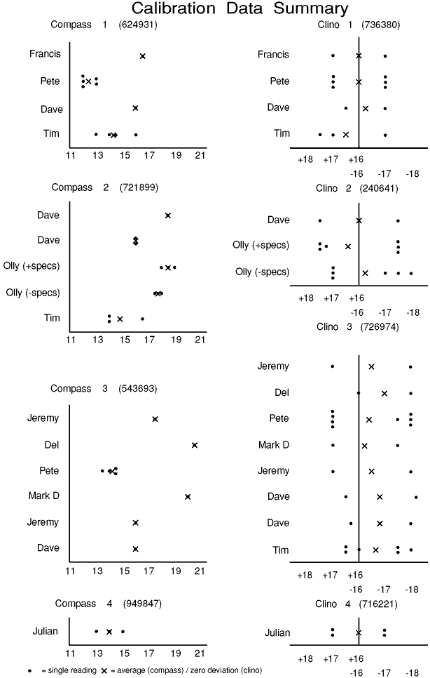
Calibration for each trip/person/instrument combination should give data on instrument zero errors, eyesight parallax errors, and local magnetic variation. In actuality it did give some interesting results but failed to prove very much beyond the fact that no-one can take accurate compass readings above about 15 degrees of tilt, and that one of the clinos is about half a degree out. The system used was to build two cairns, one just by the 161(a) entrance and one about 20 metres away along the ridge, then paint the tips of both to avoid confusion over exactly which points to use. These cairns were (ideally) used by each instrument reader before each trip for a compass reading from bottom to top and for clino readings both ways. A compass reading from the bottom cairn to the Bräuning Nase was also taken in some cases. All readings were preferably read several times to give an indication of repeatability, and to improve accuracy. The position of the bottom cairn was determined by taking bearings on surrounding hills.
This calibration, whilst not being carried out on every trip, was done sufficiently often to give some interesting results.
| Date | Insts | Where | Comp | Clino |
|---|---|---|---|---|
| 12/7/90 | Juliette/Wook | Adrians-161b | ||
| 13/7/90 | Jeremy | 2 Year Gestation | 2 | 4 |
| 14/7/90 | Julian | Pit and Pendulum | 4:15,13,14 | 4:+17,+17,-17,-17 |
| 14/7/90 | Matt | Rabbit Warren | 1 | 2 |
| 18/7/90 | William | Flat Battery | 1 | 1 |
| 18-19/7/90 | Jeremy | Bullshit alley | 3 | 3 |
| 18-19/7/90 | Dave F | Vestabule, CFN | 2:18½ | 2:+17.5, -17½ |
| 19/7/90 | Animal | Dreamtime | 1 | 1 |
| 19-20/7/90 | Del | Too Much | 3:20½ | 3:+16, -18 |
| 20-21/7/90 | Pete/Dave F | Endless | 3:14½,14,13½,14½ | 3:+17x4,-18,-18,-17½,-18 |
| 21/7/90 | Francis | France, FC II | 1:16½ | 1:+17, -17 |
| 21/7/90 | Mark D | Flat Battery | 3:20 | 3:+17,-17½ |
| 22/7/90 | Dave H | Splatdown | 2 | 2 |
| 24/7/90 | Pete? | Umleitung | 1:12,12,13,13,12 | 1:+17,+17,+17, -17,-17,-17 |
| 26/7/90 | Jeremy | FB Phreatic | 3:16 | 3:+17,-18 |
| 28/7/90 | Matt | Vd1-2YG-161b/c | 2: | 4: |
| 28/7/90 | Dave | 163/Surface | 3:16 | 3:+16½,-18.2 |
| 28/7/90 | Olly | RWS and Belgium | 2:19,18½,18 (18,17½,17¾) | 2:+17½,+17½,+17½, -17¼,-17½,-17½ (-18,-17½,-17,+17,+17,+17) |
| 29/7/90 | Dave F | 162 | 2:16,16 | 3:16.3,-18 |
| Dave F | Captive Wedge | 1:16 | 1:+16½,-17 | |
| 3/8/90 | Tim | Bolt connections | 1:16,13,14,14½ | 1:+17½,+17,-17 |
| 5/8/90 | Dave F | Adrian bolts | ||
| Paul | 161b-161c | 4 | 2 | |
| 6/8/90 | Dave F | Sheared off KB | 1 | 1 |
| 6/8/90 | Tim | Powerstation | 2:016½,014,014 | 3:+16½,+16,+16½,-17½,-18,-17½ |
Compass numbers: 1  624931        Clino numbers: 1  736380
                 2  721899                       2  240641
                 3  543693                       3  726974
                 4  949847                       4  716221
There were 22 Surveying trips in Kaninchenhöhle this year, along with 3 others down 162, 163 and Two Year Gestation Höhle.
Right - what did all this lovely data show us? Plotting the readings for each clino (see graphs overleaf) was quite instructive as they were all pretty consistent and one of the clinos is obviously about 0.7° off its zero. The compass data is much less conclusive. These results are very scattered, despite the fact that the results for one individual are usually consistent. So much so that nothing can reasonably be decided about their zero accuracy. I think the variation shows just how inaccurate readings taken at inclinations above 15° are. Note that even the only readings taken by the same person with the same compass are different. Conversely the relatively few readings taken on the Bräuning Nase were much more consistent (presumably because they were nearly horizontal).
In the light of the above, next year's compass calibration will be done more horizontally to see if more meaningful results can be obtained.
The computer used this year was Wadders' Archimedes. This did a sound but phenomenally slow job of pretending to be a PC in order to run Sean Kelly's Surveyor '88 ('89 version). After much faffing with discs to get the software working, the system proved very useful as the survey data was entered as soon as it came down the hill (we didn't quite resort to radioing the data down!) and so centre lines of new passage were immediately available for the original surveyors to check for errors. Olly's program to improve the display end of the process also helped as its real-time rotation provided much better comprehension of the displayed passage than was possible otherwise.
This almost instant and versatile graphical display of the survey data was helpful in allowing visualization of the relative positions of different bits of cave. A system which showed some sort of representation of the walls as well would be even better and a prototype may be available for use on Austria '92.
Whilst on the subject of surveying, and having just drawn up the survey, here is probably the best place to mention various criticisms of surveying technique which have become apparent this year, mostly highlighted by the overall improvement in standards.
When surveying pitches all plans that have no means of identifying their orientation are practically useless. Either a bearing or more than one survey point is needed. Also, when surveying vertically, think of the whole process as having tipped through 90 degrees along with the cave, so each little plan becomes a 'cross section' and you should draw elevations of the whole thing, instead of a horizontal plan. These elevations are obviously likely to have lots of dotted lines, but if you don't draw something the survey drawer is just going to have to guess which is not too hot.
Along similar lines it is also extremely useful to draw an extended elevation along the line of the survey/ passage. This effectively fills in the third dimension and again saves the drawer guessing what is between each cross-section. Hardly anyone in CUCC has done much of this so far, so it will be a new thing for you all to forget to do in future.
Fortunately for you lot I have lost my list of specific survey whinges which named names and pointed fingers so ... Ah, no, here it is. Now, I don't want anyone to take this too personally and feel pilloried or whatever. I just think that the best way for people to improve is to get some constructive criticism, and all you newies can see what everybody else did badly and try to avoid making the same mistakes.
So here goes:
Starting with the couple of things mentioned above. Those guilty of unaligned pitch plans are Olly and Tim (Powerstation), Jeremy and Dave F (Captive Wedge et al.), Del and Dave H (Splatdown) and Wookey (Vestabule and 163). As already mentioned no-one did any extended elevations except bits by Francis (Bullshit Alley), Wookey (Vestabule), Tina (Dreamtime), Hugh (French Connection II) and Matt/ Pete (Umleitung).
Now I know that LRUD (Left, Right, Up, Down) data is a slightly contentious issue, but unless you are going to draw cross-sections at each survey station, you should write down the LRUD information as it defines the position of the station in the passage. One point which seems to be unclear about LRUD is exactly what distances to give. You should aim to define the distance of the station from the general outline of the passage, ignoring small-scale twiddly bits. Where a reading is meaningless (eg. you are at a junction and there is no sensibly defined left wall) then put a dash, where you don't know (eg. the roof is too high to see) then put a question mark. In cases where LRUD would be misleading (eg. where there is a significant floor trench) then an annotated cross-section will be much clearer. Also note that left and right are normally defined looking in the direction of the survey.
Those guilty of not including LRUD information this year are Pete, Matt (and he didn't have any point descriptions either), Dave H, Hugh and Tina. Also on the subject of sections Dave H and Francis should make sure they've got scales/sizes on all of theirs and Juliette should try to keep hers to scale (next year's squared paper should help).
Other complaints are: Hugh and Juliette should write their information in compass, clino, tape order instead of the more usual tape, compass, clino that everybody else uses (whilst this is not actually wrong, unless there is a good reason for it it should be avoided as it is just another source of confusion and error); Wookey should put more distances on his plans and elevations; Juliette should try to write ones and sevens so they can't be confused; Hugh wins the prize for general inaccuracy; and Tina should put more (some) passage detail in (pitches, bolts, ropes, climbs, sand etc).
Right, that's all for this year.
The other thing which has come to my notice (through Welsh surveying) is that as well as compasses being affected by alkaline batteries, some Joe Brown style helmets have something in their rim which can give a good 17 degrees of error - try yours.
I will just end all this ranting by thanking all those who put in cold, tedious hours underground in the interests of science(?), and suggest that you think back to the surveying CUCC was doing just three years ago and how much we have improved since then. No longer will we be in 'How to run a caving Expo' as the least scientific expo known to man!