Photo - Photo GPS is unreliable
Philip S.
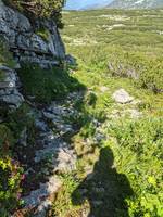
During this same trip walking to Geschandalm, later analysis of the GPS locations of various photos showed a lot of variability. This is a particularly clear example where the location is obvious in the photo (it is definitely on the path) but the GPS location stored by the phone camera is 60m away.
I had one phone (Xioami) continually tracking my location (using OSMand) which produced the GPX track,
and another (Pixel) used for photographs.
The GPS data in the photos is clearly completely wrong for some of the photos -
presumably because I hadn't left enough time for it to get a decent GPS fix before taking the photo.
This is particularly clear when there is a well-identified spot in the photo,
such as this one right by the shady cliff (photo EXIF GPS locations are orange dots):

The lesson to take away from this is to always take TWO photos at any one position, and throw away the first one. This will nearly always work for most people, and is sufficiently simple that even undergraduates can remember it. Alternatively, always continually record a GPS track on the phone you are using to take photos with - though this is unfortunately not always reliable either, as the camera app tends to cache locations and doesn't always get a fresh one from the "location" module in the phone.