1623 / 207
(96-WK2)
Plumpsklohöhle 1/T +

Surveys and Rigging Guides

1999 survey 1999 survey elev

Survey drawn up in loose leaves in front of 1996-9 NotKH book

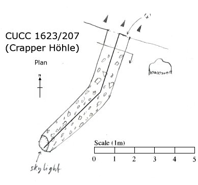
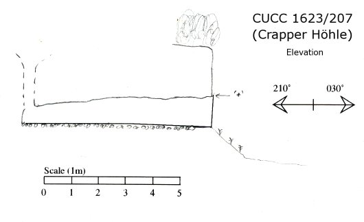
Underground Description

Small (1.1 x 0.9 m) horizontal cave about 7m long in cliff edge, very small skylight lets light in at end.

Equipment

None

Underground Centre Line

In dataset

Explorers

Scanned survey notes

1623-207

Entrances

  1. Id letter: '' Edit this entrance
    Marking
    Tag
    Marking Comment
    Paint "+" and tag.
    Findability
    Coordinates
    Location
    100m W of the waterhole at (upper) top camp. In small cliff one step up from top camp level. Entrance faces N. 16m S of 1623/208.
    Approach
    From Top Camp (upper site) walk along "crapper" shelf, following path. After 80m where path goes down to next shelf, climb 3m step ahead. 207 is to the left (and 208 to the right).

    Surface survey location sketch in not KH 1996 p 3, area map: NotKH book pp68-69

    Photo(s)

    Photo © Dave Loeffler 2005

    Bearings
    VSK (obvious point = Nipple ?) 103°, HSK (leftmost top) 052°, Schönberg 346°
    Other Station
    1623.p207 - from surface survey 47.67928N 13.80367E (UTM33 5281348, 410208), 1711m

New Entrance

Survex File(s)

All survexfiles for this cave
Primary survex file for this cave
Download .3d file /cave/3d/1623-207.3d
cave reference '1623-207'
cave survex path '1623/207/'