Surveys and Rigging Guides
- Plan, post-2006 Expo [3108k; 6696x12126 pixels, colour] or greyscale version [570k; 1410x2554 pixels]
- Plan, post-2005 Expo [2696k; 4234x7000 pixels, colour] or 1601k gzipped SVG or 8898k PDF
- Plan, post-2004 Expo [1497k; 5722x10764 pixels, colour]
- Plan, post-2003 Expo [760k; 3654x5699 pixels, colour]
- Plan, post-2002 Expo [702k; approx 2400x3200 pixels, greyscale] or 1.8M gzipped postscript
- Plan, post-2001 Expo [511k; approx 2500x3500 pixels, greyscale]
- Plan, post-2000 Expo [79k; approx 2300x3300 pixels, monochrome]
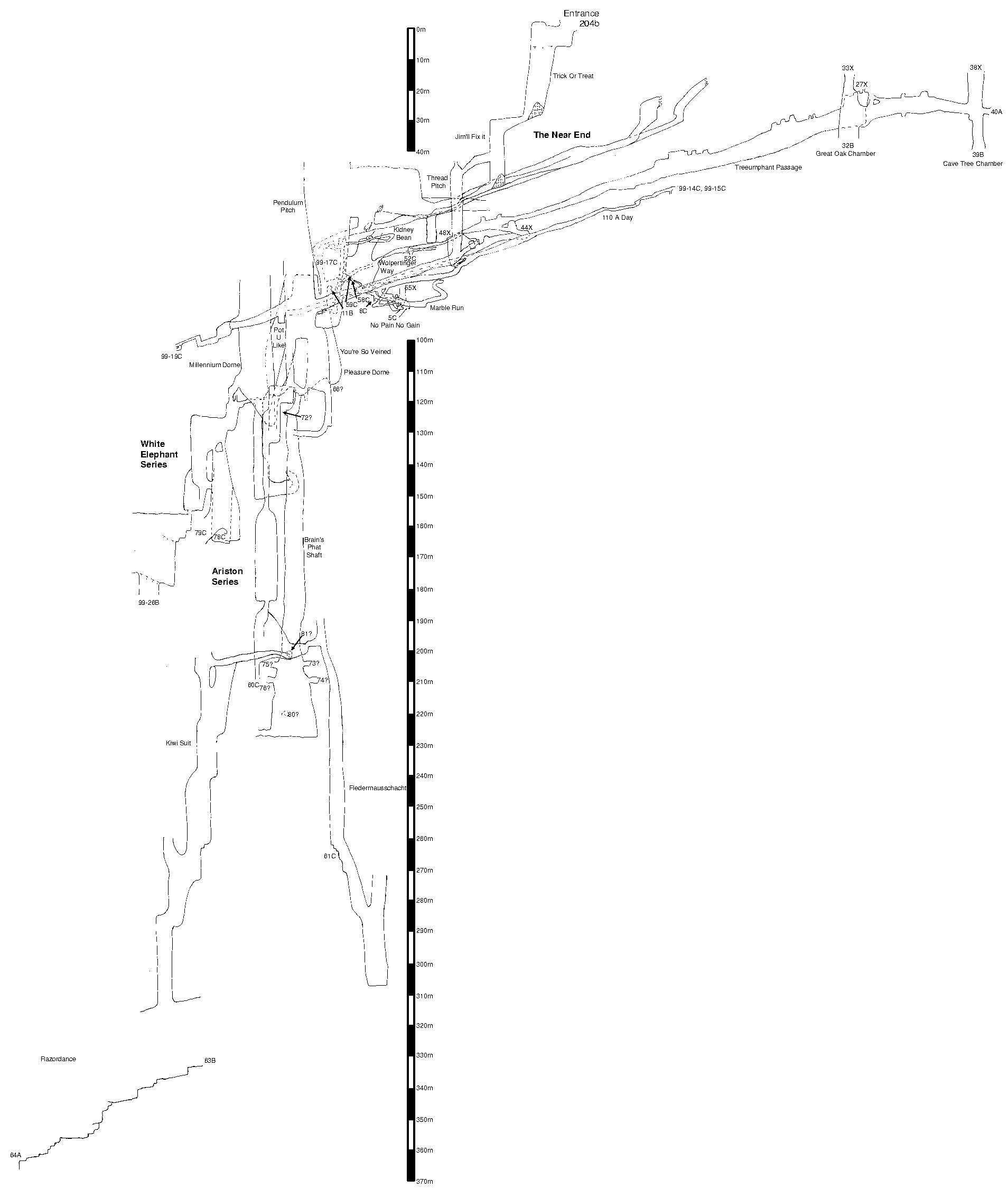
- Elevation, post-2000 Expo [22k; approx 1900x2200 pixels, monochrome]
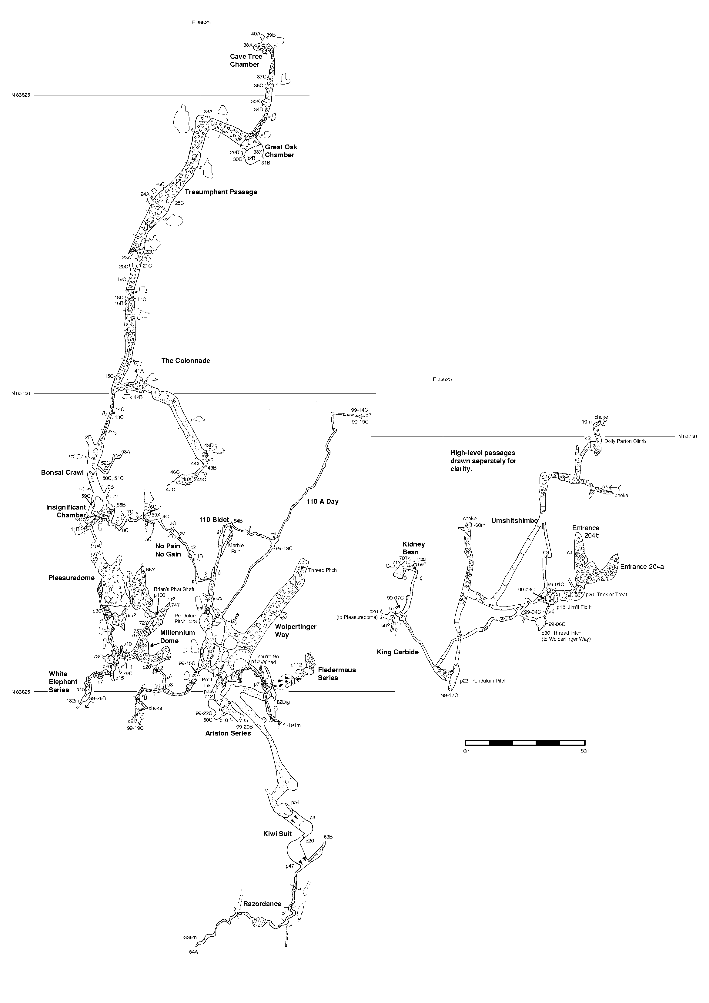
- Plan, post-1999 Expo [26k; approx 582x783 pixels, greyscale]
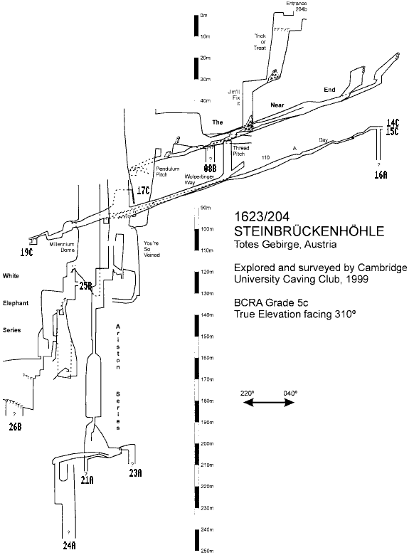
- Elevation, post-1999 Expo [16k; approx 432x586 pixels, greyscale]

Extract from the 2006 survey, purely to show a pretty picture.
Underground Description
- Entrance and The Near End passages
- Mid-level passages (including Wolpertinger Way)
- Deep routes via the Ariston Series
- No Pain No Gain, Pleasuredome, and Millennium Dome / White Elephant area
- Trunk way through Treeumphant Passage to Cave Tree Chamber and beyond
- Swings and Roundabouts area
- Rhino Rift
- The Underworld
- Convenience Series
- Subsoil
- Subway Series
- Glossary of passage names
- Photo gallery
Explorers
- CUCC 1999 to length 1365m, depth 226m
- CUCC 2000 to 2.5km, depth 368m
- CUCC 2001 to 4.7km, depth 368m
- CUCC 2002 to 5.3km, depth 454m
- CUCC 2003 to 7.2km, depth 510m
- CUCC 2004 to length 9.1km, depth 542m
- CUCC 2005 to length 11.7km, depth 542m
QMs
QM page for 1623-204Wallets: scanned survey notes
There are 214 wallets with data for this cave:1999#11 1999#12 1999#13 1999#17 1999#18 2000#02 2000#03 2000#13 2000#14 2000#18 2000#24 2000#26 2000#28 2000#29 2000#38 2000#39 2000#40 2000#41 2000#42 2000#43 2000#44 2000#45 2000#46 2001#01 2001#02 2001#03 2001#04 2001#08 2001#09 2001#12 2001#13 2001#14 2001#20 2001#21 2001#22 2001#24 2001#25 2001#26 2001#29 2001#31 2001#36 2001#37 2001#40 2002#13 2002#15 2002#18 2002#19 2002#20 2002#23 2002#24 2002#27 2002#28 2003#02 2003#04 2003#05 2003#06 2003#07 2003#08 2003#09 2003#13 2003#14 2003#15 2003#16 2003#17 2003#18 2003#20 2003#24 2003#25 2003#26 2003#27 2003#28 2003#32 2003#35 2003#36 2003#37 2004#02 2004#06 2004#09 2004#10 2004#11 2004#12 2004#25 2004#26 2004#28 2004#29 2004#30 2004#31 2004#32 2004#33 2004#36 2004#42 2004#43 2004#44 2004#52 2004#55 2005#01 2005#02 2005#03 2005#04 2005#07 2005#09 2005#10 2005#11 2005#15 2005#16 2005#17 2005#18 2005#19 2005#24 2005#25 2005#27 2005#29 2005#34 2005#35 2005#36 2005#37 2005#42 2005#44 2005#47 2006#01 2006#02 2006#03 2006#04 2006#08 2006#09 2006#19 2006#22 2006#26 2007#05 2007#06 2007#07 2007#08 2007#09 2007#10 2007#11 2007#12 2007#13 2007#15 2007#16 2007#17 2007#18 2007#19 2007#20 2007#21 2007#22 2007#23 2007#25 2007#26 2007#27 2007#29 2007#32 2007#38 2007#39 2007#40 2007#43 2007#44 2007#51 2007#52 2007#61 2007#99 2008#01 2008#02 2008#03 2008#04 2008#05 2008#13 2008#16 2008#19 2008#20 2008#32 2008#33 2008#38 2009#02 2009#04 2009#05 2009#06 2009#08 2009#17 2009#18 2009#19 2009#21 2011#01 2011#02 2011#03 2011#04 2011#05 2011#06 2011#07 2011#08 2011#09 2011#12 2011#13 2011#14 2011#16 2011#18 2011#22 2011#23 2011#25 2011#26 2011#50 2012#01 2012#03 2012#04 2012#05 2012#07 2012#09 2012#10 2012#21 2012#22 2012#25 2012#26 2012#27 2012#35 2012#45