Loser Plateau - Surface documentation work
Mon 01 Aug 2005
Dave
All the above numbers are from Wook's Garmin GPS12, which was persuaded to produce dataset coordinates with the following settings: Position Format: User Grid; Longitude Origin: 13° 20' E; Scale 1.0; False Easting 0; False Northing 4800000; Austrian datum.
Dave
In the course of a long and inordinately tiring surface walk, visited the following caves:
- 207 + 208: Both already tagged; took photos.
- 159: ditto.
- 145: Photoed main + b entrances. Took a photo of what we think is 145c, but didn't tag it as we weren't sure.
- 156: already tagged, so took photo.
- 1997-07: took photo.
- 209: found it was not tagged, contrary to what the list said, so added a tag and took a photo.
- 136: sorted out by decree the confusion over which of b, c + d entrances is which, and took photos of them.
- 135: tagged
- 225: tagged, GPSsed and photoed. GPS 35931 82452 1738m (dataset coords).
- 96WK12: added a tag "2005-89" and took GPS fix: 35694 82252 1694m.
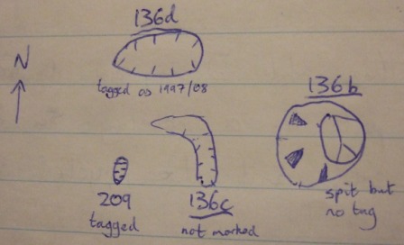
[Sketch of entrances, labelled]
All the above numbers are from Wook's Garmin GPS12, which was persuaded to produce dataset coordinates with the following settings: Position Format: User Grid; Longitude Origin: 13° 20' E; Scale 1.0; False Easting 0; False Northing 4800000; Austrian datum.