
Note: With the vast increase in the use of GPS units I think it's a fair while since anyone used bearings for locating new entrances, but this document is still relevant as this is the only information we have about a number of already explored caves. —DL 2004.04.22
In the long term, every cave that gets a number should be on a surface survey carried out to the same accuracy and with equally good sketching as the underground surveys (see the Surveying Guide). Failing that, a good GPS fix should mean that the immediate vicinity can be found again. However, for prospecting and initial exploratory work, it is usually good enough to take bearings from the entrance and make a good sketch or take photographs.
In theory, any cave can be located by taking bearings to two other known points. For this to work at all well, the bearings should be as nearly as possible at right angles to each other, and the points should be clearly recognisable, well-defined and not too far away. As these criteria are not always readily met, it is usually worth taking extra bearings on several points (ie. at least three) which can be used for confirmation or for spotting duff ones.
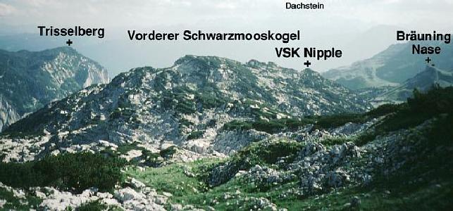
In general, sharp pointy peaks which can be recognised over quite a wide area are best, so that the Bräuning Zinken is excellent. Peaks with very rounded or multiple summits are generally not useful, so that the Vd. Schwarzmooskogel, for example, is particularly bad. In this case, it is useful to include a sketch to say exactly which point was used. The apparent summit, as seen from Top Camp, is usually called "VSK nipple". This is a good 50m below the true summit, but appears well-defined. It is fine for finding caves in the field but is not adequate for locating them on a map.
In the cave descriptions, bearings are quoted with a series of standard abbreviations for landmarks, which gives a good indication of which ones are most useful.
Ideally, take bearings on one of the points identified in the pictures below (follow the links to useful sized images on which the peaks are named). Failing that, be sure to identify your feature correctly, using a good map (ie. the Alpenvereinkarte 1:25000 sheet 15/1, Totes Gebirge West), and write down the name in full, preferably with a sketch.
|
|
|
| A view of the Bräuning Wall (from far out on the plateau) showing which peak is which. | A view showing how the Bräuning Wall becomes foreshortened from the "near" plateau and approach to Schwarzmooskogel ridge. |
|
|
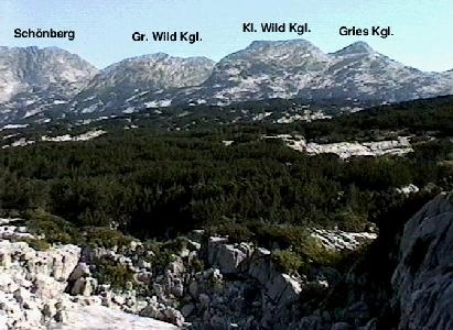
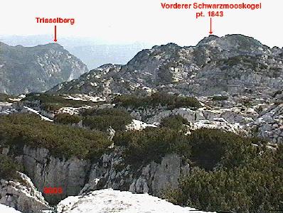
| A view identifying the peaks visible to the north of the plateau - Schönberg, Große and Kleine Wildkogel and Grieskogel. | A view of peaks seen south from the east side of the Hinterer Schwarzmooskogel. |
|
| |
| A view south from Hinterer Schwarzmooskogel showing the Trisselberg to the left and behind the serried ranks of false summits on the Vorderer Schwarzmooskogel. On the far right, Bräuning Nase can be seen. | |
(More views to follow - however, there's no point until we have actually identified the summits on the views with complete certainty :-)