The main software we use to process cave data and surface surveys is survex which has been written over several decades by CUCC cavers. The first version was written during the 1990 Expo in Austria in the old potato hut. A history of survex article was published in Cambridge Underground 1996. It covers the period 1988-1996.
Download the survex package here: www.survex.com and install it.
You will discover that the application installed is actually called "aven" but do not be concerned. This is what you will use to visualise .svx files as beautiful cave centre-line surveys.
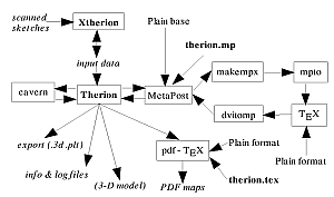
If you are entering new survey data from a new cave, you will also need either TunnelX or Therion to convert your sketches into actual plan and elevation presentation-quality surveys.
Tunnel was written by Julian Todd (18 Austrian expos since 1989). It allows the generation of full 3D models of cave passages which can be viewed using a VRML browser.
TunnelX detailed wiki documentation (old).
Article by Wookey: Drawing Surveys with Therion (Compass Points, March 2004)
GPS is increasingly important for all the surface work.
GPS Prune is a vitally useful utility.
TopoDroid is an Open Source Android app to make cave surveys with the DistoX. TopoDroid is an Open Source Android app to make cave surveys with the DistoX.
Features:
* communication with the DistoX device(s),
* support A3 and X310 DistoX * data stored in a SQLite DB.
* surveys management: stations entry, notes and comments.
* exported survey formats: Therion, Compass, Survex, VisualTopo, DXF, csv.
* imported survey formats: Therion.
* sketch drawing, Therion-wise with points (symbols), lines and areas. Saved as th2 files, PNG images, and DXF files.
* user-defined drawing symbols.
* save whole survey as ZIP archive, and restore from it.
* 3D display (using Cave3D). * photoes and GPS localization (using GPSaverage).
* internal sensors measures and external measures. * DistoX calibration.
Loch This is fork off of Therion's loch program. The goal is to model Cave systems in 3d and have a high degree of interaction between the user and the information. There is currently no working version and it has not been updated since 2007.
TopoLinux consists of cave surveying applications for Linux PC and Android devices. Apparently superseded by TopoDroid and other tools on that website.
psurvex
"A Survex compatible cave survey data processor for Psion palmtop computers" by Matt Ryan, 2004.
My task was to write a new program which could read the data from an external file,
ideally one which resembled a .svx file as much as possible.
Psurvex supports
only a subset of the .svx file format but the same file should process in Survex
without any problems. You need to write a .svx file and save it somewhere on your machine.
This program will then process the file and create a second file containing a list of
points for plotting on graph paper and some statistics about your survey.