1623 / 268
(96WK11)
Neunzehn Yahr Wartezeit Höhle 1/S -

Surveys and Rigging Guides

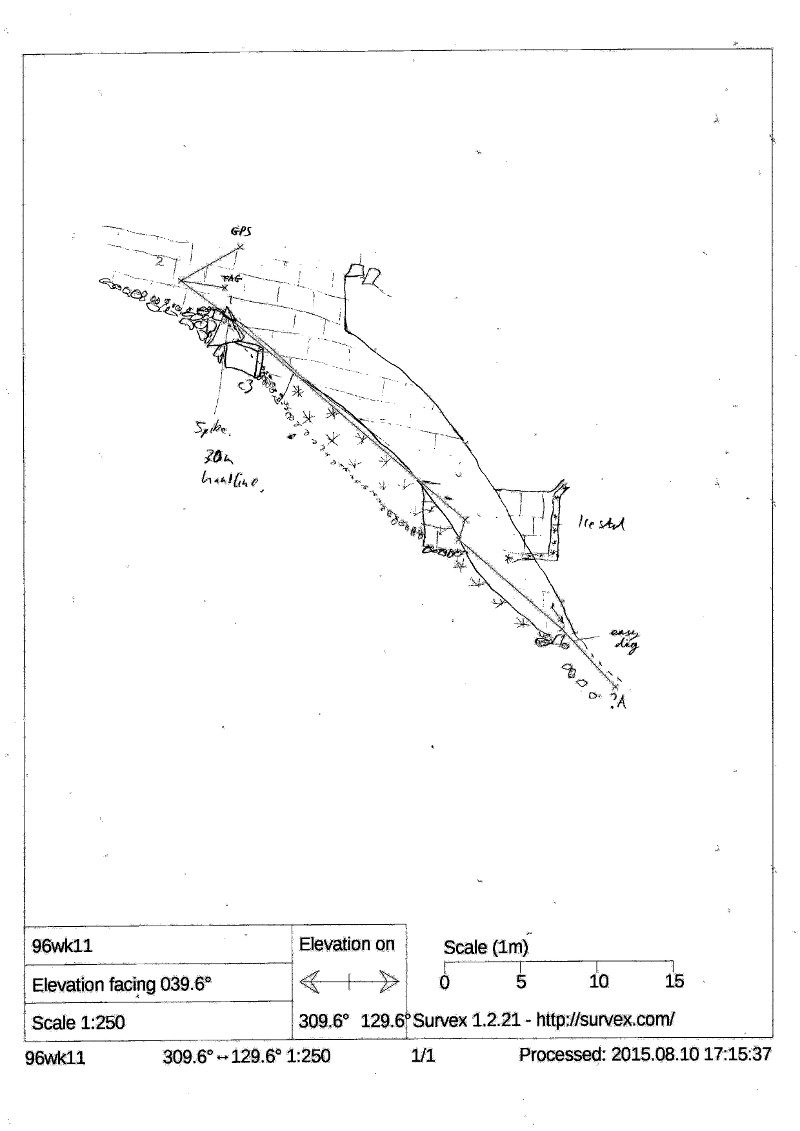
1996 Sketch plan and elv in NotKH book 1999- p16
Proper survey 2015

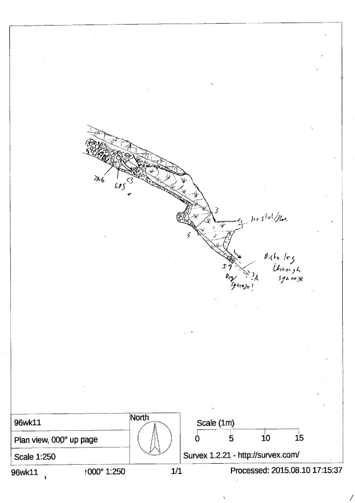
Underground Description

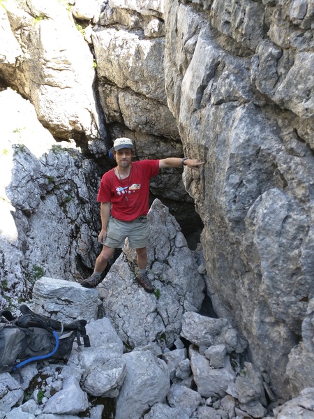
Steeply-descending canyon, aligned 115<->295°, 3m wide with boulder floor. The Tag is in the RH wall looking into the hole (south-eastwards), above a large pointy boulder. The GPS point is ~3m above out of the canyon.

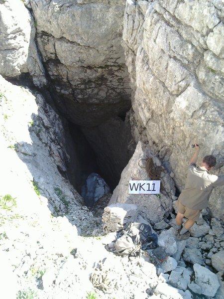
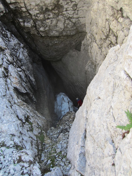
A 30m handline is needed for descent as it is steep and (in 1996 and 2015) containing a snow-slope/ridge. Belay from the pointy boulder. A C3 drops onto the snow-ridge. Progress down the side is possible, descending about 10m from where you continue on top of the snow. There is a alcove on the R, and opposite an ice waterfall comes in from above. Descending another few metres the roof comes down and the snow peters out at a slot blocked with rocks. There is a draught here (inwards on a sunny day (2015-08-09)). 4m more narrow but passable passage can be seen through the slot. It would be a trivial dig to make it big enough to prgress, but some gear would be needed as it definitely stops being T-shirt caving at that point. This is a QM worth returning to one day.

Elevation on centreline of 96Wk11

Plan on centreline of 96Wk11

Equipment

25-30m handline, Long sling

Explorers

CUCC 1996,2015 (Wookey, & Philip Balister in 2015)

References

Logbook 2015

Wallets: scanned survey notes

There are 1 wallets with data for this cave:
2015#69

Notes

2015#69

Entrances

  1. Id letter: '' Nuenzehn Jahr Wartezeit Höhle Edit this entrance
    Marking
    Tag
    Marking Comment
    Tag (placed 2015) scratched 'WK11' due to lack of stamps - needs updating to 1623/268
    Findability
    Coordinates
    Location
    At foot of slope from top of VSK, on Eastern side, before flat area containing Nipple to south of VSK.
    Approach
    Best aproached from Top of Vord. Descend grassy SE side down to largish ledge. Head SSW on a traverse level about 150m, (passing the sizeable hole of 140 (unmarked) after 80m). Next, head down East quite steeply, passing large hole of 155 (marked) after 50m. 96wk11 is one level below.
    Underground
    One of 14 entrances marked by Wookey on a couple of walks in 1996. This once took 19 years to get round to actually exploring and recording properly. (It's easy to find entrances - hard to re-find and explore them!)
    Photo(s)

    Description
    3m-wide canyon descending into a portal. Obvious from the west, looking east. Wookey indicates tag location in pic.
    Explorers
    CUCC
    Bearings
    Nipple: 202°, Trissel: 179°, Hollweiser: 138°
    Other Station
    1623.p268 - pre selective availability GPS 47.6752258N 13.8150624E (UTM33 411056, 5280884), 1745m (SRTM is +54m, distance from reference: 19m)

New Entrance

Survex File(s)

All survexfiles for this cave (if any)
Primary survex file for this cave
Download .3d file 1623-268.3d
cave survex path '1623/268/'