Entrances
-
Id letter: 'a'
2024-ND-01a
Edit this entrance
- Marking
- Unmarked
- Findability
- Coordinates
- Location
- 47.69789, 13.81910
- Date last visited
- 2024-08-03
- Approach
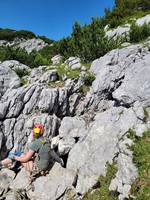
- Drafting entrance amoung boulders below a pine tree
- Underground
- 22m vertical tube 6m in diamater, ending in a large ice plug with a possible QMC at the base
- Photo(s)

- Description
- boulder removed leaving drafting hole around 0.5 by 1 m
- Explorers
- Nat, Sarah, Rosa, James W, Lucy
- Location
- WGS84 Lat.: 47.6978900 N, Long.:13.8191000 E
- Tag Location
- 1623.p2024-nd-01 47.69789N 13.81910E (UTM33 411398, 5283398), 1815m (SRTM is +38 m, distance from reference: 28m)