Entrances
-
Id letter: ''
2018-NTU-01
Edit this entrance
- Marking
- Tag
- Marking Comment
- Tagged on 13 Aug. but no record of exact tag text.
- Findability
- Coordinates
- Location
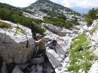
- To reach this cave easily from Top Camp, just follow the Tunnocks path until the cave marked on GPS as "1623.p2001-02", then turn right (uphill) and go up a small chive and boulder-filled gully until you see the big boulder with the tag on it.
On a scramble parallel to (east of, uphill from) the path to Tunnocks. Located in a gully filled with wild chives.
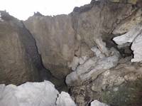
The entrance is below a large fixed boulder with the tag on its SW side.
- Photo(s)
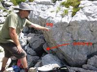
- Tag Location
- 1623.p2018-ntu-01 47.69197N 13.82165E (UTM33 411579, 5282737), 1834m (SRTM is +41 m, distance from reference: 20m)