1623 /
176
(90/6)
|
Plateau Schacht 90/6
|
1/S -
|
Underground Description
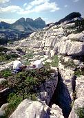
c30m shaft with snow-covered ledge at 15m. Rocks thrown down land on cobble floor.
Explorers
Recorded CUCC 1990
Entrances
-
Id letter: ''
176
Edit this entrance
- Marking
- Tag
- Marking Comment
- Originally marked "CUCC 90/6" in red, changed to "176" in 1991, on scar above cave, rather small. An Austrian metal tag bolted to entrance next to the number in 1995.
- Findability
- Coordinates
- Location
- At foot of SE-facing scar, just NE of a much more obvious (but unmarked) NW-SE rift with snow. Below this scar is a pavement formed in a shelly band of limestone, which dips c 10-15° on a strike of 135-315°. Following the pavement down and dropping down one scar leads to 175.
- Photo(s)
- Tag Location
- 1623.p176 47.68745N 13.80843E (UTM33 410579, 5282250), 1668m (SRTM is +54 m, distance from reference: 25m)
- Bearings
- Hinterer Schwarzmooskogel 102½ (1995, to left hand peak; 1990/91 100 or 104°?), rightmost (of three) peak of Vorderer Schwarzmooskogel 168½° (1990/91: 167 or 169°), Bräuning Nase 195° (1995, 1990:193°), Bräuning Zinken 220½ (1995, 1990/91 220 or 214°), Top Camp 192° (1991?)
New Entrance
Survex File(s)
All survexfiles for this cave (if any)
Primary survex file for this cave
Download .3d file 1623-176.3d
cave survex path '1623/176/'