Surveys and Rigging Guides
Grade 3 plan and elevation in Cambridge Underground 1988, p 6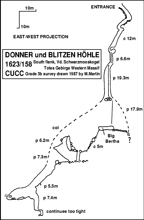
Underground Description
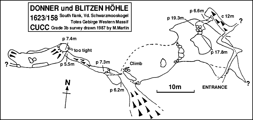
A body-width passage formed by a wall on the left and a large detached slab on the right descends for about 5m at 45°, with occasional glimpses of daylight above. A cross passage is then encountered. To the right is blocked after a few metres, but left descends to meet the base of the wall. To the right here, a 20-22cm squeeze is passed by lying on one side. After 2m of further tight progress, the rift opens onto a drop. A steep tube descends for about 12m to a small chamber and with care can be descended free.From the chamber, the passage curves to the left and opens onto the head of a 7m pitch, which drops onto a large ledge. A rebelay just over the lip of the ledge at the left hand side gives a further 18m free-hanging pitch to a landing on boulders several metres across, which appear to be jammed across the shaft.
A narrow rift around a corner stops at a drip and a small pool. The way on is through a gap to a hole with a jammed block. Climbing down to the block leads to the head of an 18m pitch which rapidly opens into a huge split-level chamber. The pitch lands on Big Bertha, a boulder some 4m in diameter.
To the north, a narrow rift has been followed for about 10m to a tight vertical drop of at least 5m down the rift, but this has not been pushed. East from Big Bertha leads to a 5m drop to the lower half of the chamber, which is floored with loose rock. An archway to the left leads to a 7m pitch to a small stream. This disappears down an impassable slot, but is met lower in the cave.
From the archway, a climb up behind a boulder propped against the side of the chamber leads to a col. One side rapidly curves up to the roof. The other ascends over very loose boulders for at least 25m (15m vertical) until the roof is met. This area has not been exhaustively pushed, but seems unlikely to lead anywhere.
Descending the other side of the col gives a series of ledges via 5m, 7m and 8m pitches, in a canyon some 5m wide and at least 15m high. The stream enters at the bottom of the 7m pitch. Below, the rift continues down a moderate slope and round a corner, with a final short 4m pitch to a soil and rock floored chamber.
A strong draught is felt around the edges of the chamber, rising from the choked floor. It is possible to descend in loose boulders in a number of places but all ways meet the roof and choke - pushing in this area is dangerous and unpromising.
Near the bottom of the previous pitch, a 5m deep circular pit in the floor can be descended. This takes a large drip from the stream above. At the bottom, a tight (22-26cm) rift leads on for 3m to a further 3m pitch to a small chamber. An impassable passage continues, while a small window gives a view of a widening beyond.