
Click for for larger image
First, look at the index list of cave numbers. Under the 1623 heading you will see a lot of caves numbered with 2 or 3 digits, e.g. 115 Schnellzughöhle and many more labelled with a year number and some letters and numbers, e.g. 2015-DL-02 Chossy Death Slope Höhle. The former are the Austrian kataster official numbers, the latter are CUCC Expo numbers which are either for caves too insignificant to be issued an official number, or where we have not yet got around to doing the paperwork.
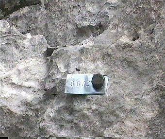
There is now a prohibition on painting numbers on entrances within the Naturschutzgebiet (Nature Reserve) area. You may see faded remenants of such numbers still. Since the early 1990s the Austrians have been marking caves with a numbered alloy tag bolted to the cave entrance. This also has the advantage of a definite fixed point to take the survey to.
We still (2023) use numbered alloy tags, but there is a move to replace this with a properly-managed and accessible GPS system. However the ~5m practical accuracy of the GPS, the multitude of holes within 5m and difficulty of accessing the entrance locations online on the plateau, mean that tags are still very useful; but we need photos of the tags showing exactly where they are around the pit.
Note that tags are all in UPPER CASE for the simple reason that we have only one set of letter punches and they are only capital letters.
From 1996, we have had to abandon the system (which we believed worked pretty well) whereby we had a block of numbers allocated from the Austrian Cave Kataster, which we could use to number newly found caves.
Nowadays we have to produce documentation before we get an 'official' number, which usually means an extra visit with someone who knows the cave's location in the year following exploration. Such a someone will not necessarily exist, which is a recipe for the number of "missing" caves increasing rather than decreasing. However, it is the Austrians' kataster, and we have to work with their system.
To overcome this limitation, and try to stop losing caves in which we have invested effort, CUCC now applies its own unique number to each new cave, ideally at the time of discovery, using a rock anchor and a tag which can be replaced when an 'official' number tag is available.
As of 2000, the standard practice has been to allocate initial numbers of the form "year-nn", e.g. 2003-01. This means that the cave can be identified when refound, even if no-one who knew where it was came out in subsequent years. Clearly, a good record of the surface location is also pretty essential.
There are also a number of caves tagged with numbers of the form "year-xx-nn" where xx are the initials of the discoverer (eg 2002-AD-01). This means that there is no duplication during an expo with many people prospecting at the same time.
Anything longer than 10m needs a number, a survey of appropriate accuracy, location information (GPS or bearings from entrance to known points, entrance photos and description of route to entrance as a minimum - surface surveys are really required for caves within a reasonable distance of existing known points, a GPS fix is essential but insufficient on its own.
In an area with many pits, a sketch is better than a photograph to distinguish the entrance from all the other holes.
If a cave is not readily apparent from the immediate area, bearings or a GPS fix will be inadequate to refind it, and a good sketch or photographs of the entrance and its surroundings will be necessary. Record all these in the logbook writeup of your prospecting trip and put the original copies of your notes in the survey wallet.
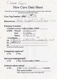
Eventually you will need to record the existance of a new cave and its entrance(s) in the Expo online system. Before you do this though, fill out a paper New Cave Data Sheet so that we don't lose vital information.
The Austrian caving organisations have a standard cave grade categorisation which is worth writing down as soon as you have explored enough of the cave. So, for instance, Kaninchenhöhle, 1623/161, gets the code "5/S/E ×", because it is 22 km long and just over 500m deep (both rate a "5"), is principally a vertical cave ('S' for schacht), but also has passages with ice ('E'), and been extensively explored, but there are still many leads to push (x).
Caves which require further exploration should be marked "-". Caves which have been fully explored and surveyed marked "|+|". This includes minor holes less than 10m in length. (Note that prior to 1996, completely explored caves were marked "+". Any un-numbered caves found so marked need to be explored again and documented (in the "Noted" list, as a start). A number as above should be allocated if they exceed 10m in length).
There are many other caves marked just with a "+" symbol and a few which just have bolts and no numbers. In the past, any cave which could not be seen not to go just from a surface look has been marked with a "+" to show that it has been looked at but didn't go anywhere significant. We are supposed to record these for the Austrians, so if you find one, please mark it with a unique identifier and record where it is, even if you don't have time to re-explore it at the time. This will help us to assess how many of these caves there are, and to target areas where there are lots first. Overall, this should reduce the amount of work needed to "catch up".
Having come upon a known cave, and decided on the action needed from the tables, you can find out more about the cave by looking at online cave descriptions e.g. at 291 Glückliche Schmetterlingshöhle. Look in the Index to all caves.
For caves being currently explored, a more complete view of the raw data can be seen in the current wallet status of the cave.
This all exists mainly to ensure that anyone (not just CUCC) finding a cave marked or previously explored by CUCC can find out all we know about it.
For CUCC's caves, we must supply at least a certain minimum of information to the Austrians, which includes an accurate location, state of exploration, name/marking, description and some sort of survey. Obviously for significant caves, we will want a proper drawn up survey, and the aim should be to do a survey right from the first exploration - if the cave ends, this saves having to go back again later ! If you find a cave for which adequate information is not in the database, then at worst document the lack, and at best, go out and create the missing documentation!
As other groups also work in adjacent areas to ours, it is clearly important that the information is widely available, to avoid clashes of interest or duplication of effort. All CUCC's finds are documented here, together with any other caves which we have information on, which we are permitted to publish.
We are always very pleased to receive any information on other caves in the area, to make the database more complete. It is in no-one's interest to reexplore known cave, or to intrude on someone else's ongoing project ! There is a limited amount of information in the database on caves not explored by CUCC, for which we are not permitted to make the data publicly available - none of this information has been checked in the field and is likely to be out of date, if not just plain wrong. The data are included for completeness and should help CUCC during expeditions. We can make the data available (through password-protected access to those net pages) to other groups with a bona fide need.
The non-public data is available to logged-in users, using the 'Log in' menu item at the top-right of all the handbook pages and using our usual 'cavey:beery' password or through your personal login (new in 2025).