See also:
Troggle report: UTM/G&K entrance data
Troggle report: entrances
GPS and coordinate systems
Basic Coordinate Systems.
Geographical fixed points on Loser
The Austrian Kataster areas
SD 10 Handbook: Vergleich der ÖK 50 mit der neuen ÖK 50-UTM
UK Caving: How to obtain a fixed point for a cave survey (very good)
Surveying in Austria does not just use the latitude and longitude you may be familiar with from Google maps, your phone etc.
Our grid conversion tool: convert a location
All our caves and locations in our survex files process data in the UTM33N coordinate system, numbers which look like this:
| Northing | Easting | Altitude | Description |
|---|---|---|---|
| 411563.49 | 5282622.35 | 1867.95m | p204a at the Stone Bridge |
These grid references are what we use to locate the entrances and to tie in the survey of a new cave in with the rest of the 180+ km of cave and surface surveys.
These might be called "dataset coordinates" in expo-speak, but note that some people historically used this to mean the coordinate system in common use on an expo many years ago, which would not be the same.
Note that there are 6 digits starting 41... and 7 digits starting 52... This is not a mistake.
However, when you prospecting and discover a new cave, you possibly only have the WGS84 latitude and logitude from your phone, e.g. 47.690933 N 13.821467 E (degrees and decimals of degrees, set your phone to produce this: none of that degrees/minutes/seconds stuff, but if that's all that you have, we can work with that).
So when you are recording the position of a completely new entrance, before you do any surveying, it will be the WGS84 lat/long that you will be writing down on the survey notes, and which will get scanned into the wallet back at base, and which you will enter into the New Cave and Entrance forms on troggle (step 6 of the dave data processing guide) in the lat/long. data entry fields.
We do all our serious geolocation within survex, using .svx survex files and using the conversion capabilities built into survex.
While cave entrance locations are input using a bewildering variety of different coordinate systems, the processing and output is now all standardised on using UTM33, i.e.
*cs out UTM33N
as survex puts it.
Actually, the vast majority of our historic data input has been using the GK coordinate system because that is what the Austrian cavers use (though some people thought it was BMN, so beware of mistakes in the writeups and documentation).
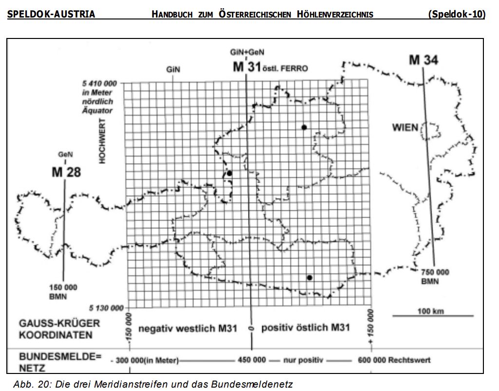
The Austrian Caving national grid system SD_10_Handbuch uses the Gauss-Krüger-Koordinatensystem(GK) (page 39 of the SD_10_Handbuch). This is 5 digits x, 5 digits y, and usually with a couple of digits after the decimal point for each.
So if you are looking at the *fix data in files in the :loser: repository, you will see this:
*cs out UTM33N
*cs custom "+proj=tmerc +lat_0=0 +lon_0=13d20 +k=1 +x_0=0 +y_0=-5200000 +ellps=bessel +towgs84=577.326,90.129,463.919,5.137,1.474,5.297,2.4232"

*fix p2000-bl-12 34554.2 86249.7 1898
Where the input coordinate system is specified using what is called a "proj4" string which defines a custom coordinate system, and that long string of settings is the string which defines GK.
In 2013 there were about 30 potential cave entrances located using a GPS device set to record data in the BMN (area M31) coordinate system.
This looks very similar to GK but has different offsets in +x_0 and +y_0 :
*cs out UTM33N
*cs custom "+proj=tmerc +lat_0=0 +lon_0=13d20 +k=1 +x_0=+450000 +y_0=-5000000 +ellps=bessel +towgs84=577.326,90.129,463.919,5.137,1.474,5.297,2.4232"

*fix p2013-bl-01 486492 284508 1859
A quick check is that both the x and y coordinate have 6 digits before the decimal point.
This is described very clearly in wikipedia.de: Österreichische Bundesmeldenetz (BMN).
[The text from this point onwards is from before we had mobile phones, but it is correct.]
It doesn't especially matter what display options are selected when you are getting the GPS fix, but it is important to use standard ones when writing down the reported position in the survey book. The usual systems are either Lat/Long with the WGS84 datum, which all GPSses support out of the box; or the Austrian BMN (Bundesmeldnetz) system, which should be relative to the Austrian MGI datum (Hermannskogel), which is what we use for our surveys. It doesn't matter too much what combination of parameters you actually use as long as you record what they were, since we have conversion programs that can convert coordinates between the systems; but remember to record which grid and which datum your GPS was set for when you copy the fix into the survey file. (Besides the risk of introducing severe errors, it is an extraordinarily tedious task to have to repeatedly try all the plausible combinations of grid and datum that a given set of numbers might be in, convert them all to dataset coordinates and see which ones give answers in vaguely the right place, which is what someone will have to do if you don't write the details down.)
If you want to set up your GPS to use the same coordinates the survey data set uses, which makes life a lot easier, then these are the runes to use as a "User Grid" if the unit doesn't support BMN coordinates immediately (which Garmin ones don't, for example):
| Ellipsoid: | Austrian (Bessel 1841) a = 63377397.155m (ΔA = 739.845) 1/f = 299.1528128 (Δf x 10,000 = 0.10037428) |
|---|---|
| Datum: | Austria MGI (Hermannskogel) |
| Projection: | Transverse Mercator (BMN zone M31) |
| North reference: | Grid |
| Grid parameters: | Central meridian 13°20'E False easting 450km No additional scaling Grid boundaries at 11°50' and 14°50' |
| EFEC coordinate conversion equation with respect to WGS84: |
Offsets Δx = -575m, Δy = -93m, Δz = -466m Rotations ωx = 5.1"; ωy = 1.6", ωz = 5.2" Scaling -2.5ppm |
Note: The table above used to incorrectly give the y rotation as 5.1". But there's a slightly more accurate version in the Coordinate Systems section.
(Technical note: the BMN grid is actually the same as Universal Transverse Mercator zone 31, but setting your GPS for UTM will give rather different coordinates, as the plateau is actually in zone 33. My understanding of the situation is that the Austrians have found it more convenient to extend one grid to cover the whole country, thus deviating from UTM for the areas of the country which are just over the grid boundary. This is an important gotcha to watch out for, since while all the other coordinate systems produce answers in recognisably different formats, UTM 33 coordinates look like dataset coordinates but are offset by a couple of kilometres. Having your GPS set to the wrong datum produces even more subtle errors - the difference between BMN grid + WGS84 datum and BMN grid + Austrian datum is an offset of around 500m to the south and 47m in altitude.)
A good way of testing that your GPS is correctly set up is to set it WGS84 Lat/Long and enter a waypoint for a point whose coordinates are known – such as the 204a tag, at 47°41.456'N 013°49.288' – and then change the settings again to use the user grid. It will now convert this point into the new grid; if you check its coordinates, it should come out as something close to 486697E, 5283699N, which are the BMN coordinates for 204a. For use in the dataset we tend to subtract the 450km offset in the easting and ignore the first two digits of the northing, giving 36697E 83699N [which means this is actually GK ].
Write down the figure that the GPS gives for each waypoint at the time (just in case some failure loses the data from the GPS memory – this has happened a couple of times in recent years, much to the annoyance of everybody involved). That's all you need to do at the cave. Get the GPS data downloaded to a computer next time you are in Base Camp (or Top Camp if someone has a laptop :-), and as a backup (expo computers break down surprisingly often it seems) write it down by hand on one of the A5 cave info sheets with all the other details of your cave and put that in the surveys ringbinder file.
If you want to read about the nitty gritty of converting GPS coordinates to the ones used by the Kataster system, you can do no better than read the short introduction to coordinate systems, which briefly says "it's horribly complicated and we use computer programs to do it properly". (A rather outdated first attempt at this can also be found in Wookey's Compass Points Article from 1996, which briefly says "it's horribly complicated and we don't really know how to do it properly".) Overall things have significantly improved since the early days, particularly as without the fog of the Selective Availability variation it's now easy to find out whether your GPS is set up right by just GPSsing a known point and comparing the results. However, the main point of having a GPS fix on an entrance is so we can find it again and be sure it is the same one!