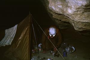
Andy Dolby in the camp, 1982
Junction Chamber is a nexus of routes where ways in from Schnellzughöhle to the SW and Stellerweghöhle to the NW meet. The Stellerweg water joins another inlet from the NE, to flow into an impassably narrow canyon below the point of entry from 115. Directly opposite this point is a very greasy 10m climb up (handline almost essential after any traffic has dampened the mud). This gives access to a NE-trending large passage which is the continuation of that on the other side of the chamber. The main way on [C1981-41-18] lies up boulders off to the left soon after the greasy climb; this is the continuing Bypass to reach the Confluence.
Above the boulder climb, a very large passage leads on, turning left and heading Northwest. Down the passage, Dartford Tunnel, is a steep descent in a huge (10m diameter) boulder strewn palæotrunk with much layered mud and surge marks. After a hundred metres, it curves to the west, the main passage section changes gradually as a choked trench develops in the floor, and this is bridged by a large boulder, where care is required. By this point, the direction is almost Southwest, just before a marked change of character. The trench turns sharp left (SE) and is lost [C1982-41-03], while the main passage turns abruptly right and develops into a high rift with a flat mud floor.
The rift continues Northwest, almost exactly parallel to the Big Rift pitches in Stellerweg, though a long way below. After about 50m, the roof suddenly lowers, and just beyond, a junction is reached. Here the passage section changes to vadose canyon, still large. Right is unproductive, but left carries on Southwest in a mud floored rift to reach a 4m climb down.
The main way continues past a small arch on the left, which leads to a small chamber with a roof inlet [C1982-41-08]. A narrow trench [C1982-41-07] cuts the floor, with the sound of a stream below. The main passage now descends steeply, passing a small roof inlet [C1982-41-09] which has washed the mud floor clean. The water flows down the passage for a few metres until it has washed out the top of a narrow vadose trench with the sound of a stream perhaps 10m below [C1982-41-10]. Carrying on down the dry passage, still Southwest, leads to the inscription "CUCC/UBSS 1981" in mud on a boulder - the limit of exploration that year.
On the left, the floor trench is joined by another canyon emerging from under the far wall, and the mud floor of the tube assumes a steeper V-shaped profile. This is the start of a traverse on dusty loose mud ledges on the right (line useful). The passage widens and becomes easier to traverse, parallel to the top of the vadose trench, with the sound of the stream below [C1982-41-10]. The trench is crossed to a flat muddy ledge on the left, and then re-crossed as it disappears under the left wall after a tight meander.
Ahead is a step up, best climbed on the right, but below this, a low passage slopes down to the top of a deep trench. Above, the climb soon leads to a junction with a sandy passage branching left to Camp Chamber (care). This continues [C1982-41-11] as a traverse above a stream (thought to be Purgatory).
Beyond this turn off, the main way turns Northwest and descends steeply to meet a deep stream canyon coming in from the right at the end of a traverse across a steep mud slope. The ledge on the near side of the canyon becomes too narrow to the left, so it is crossed (awkward) to reach a terrace sloping steeply left. Down this soon reaches a corner where an easy 4m climb down drops into the Confluence.
The climb down from the Bypass lands at the junction, The Confluence, of the Purgatory water (explored in 1981) and an inlet. Downstream in a passage only slightly bigger than the Purgatory, a wet 4m climb precedes a 7m pitch, followed shortly by the entry of a small cascade from the left (right, on survey?). Sixty metres downstream is a frothy round sump pool. This is bypassed up a steep slope sharp left, where a 3m high muddy passage leads off to a 7m pitch back down to the streamway. The streamway may be followed back up to the downstream side of the sump, showing it to be less than 10m long. Downstream, the canyon is now 1.5-2m wide and too high to see the roof. After fifteen metres is a 3m climb, and a hundred metres further on, increasingly interspersed with sporting cascades, The Twelve foot climb (p5, aka "Another Pitch") is reached. Another twenty metres on is a wet 9m pitch ("And Another Pitch") and a similar distance leads to the 7m Marlow Climb (aka "Yet Another Pitch").
The rush to depth now eases, and a hundred metres on, the passage lowers to a sharp crawl and a couple of smooth steep climbs in a hading rift. Two hundred metres from the last pitch, the verticality returns. The water can be largely avoided on these pitches of 9m Lake, 22m Letch, (with rebelay ledge halfway and followed by Commando Climb 4m). A sharp left turn marks the start of forty metres of canal, ending at the 17m Grope pitch. After another fifty metres, the 13m Subtle Approach (with awkward takeoff), marked the 1981 limit of exploration via Pete's Purgatory [C1981-41-08].
A short length of streamway now leads to the 22m The Slit, and a similar distance to the 7m Coming Soon which are both vertical. Sixty metres of high rift develops into a canal. Soon, the water deepens and the roof lowers until a low swimming duck. Beyond the 10cm airspace, the canal continues sandy floored, then turns to break out at an awe-inspiring abyss with the water thundering into the depths.
The 90m shaft of Orgasm Chasm is passed by traversing out to the left in a series of pitches which avoid the water only in fairly dry conditions (11m to a ledge, 10m to a small alcove, 6m). A 42m free hang drops past well displayed beddings to a bridge across the shaft where the route divides, with the 22m pitch following the dry way down. This lands in a boulder strewn chamber where the main water is again met. A run under this leads to a small phreatic tube and a short climb down to the start of the final pitch (12, 13, 14m) which corkscrews past ledges to a more vertical section with a damp rebelay to land in a spray lashed chamber. A short wet climb down leads to the final sump [C1982-41-17] in a rift. There is a small tube above with no draught and blocked with boulders [C1982-41-18].
This point was put at -898m by surveys at the time, but current figures (late 1999, after much new survey in the upper levels) put the sump higher (at 738m altitude) and the 41 entrance lower, giving a figure of -885m below 41, and -974m below the highest (144) entrance.
The water was originally not thought to resurge in the nearby Altausseer See, as the Austrians reckoned that this was in a different block of limestone. However, the coincidence in altitude with both the lake (at 712m) and a static sump in Liägerhöhle does suggest some control over the local water table. Following the discovery of underwater risings in Altausseer See in 1990, it now seems likely that these are the resurgence for this water. Unfortunately, permission for dye tests is quite hard to obtain, and the total flow from Altausseer See, much larger than some other possible resurgences, capped for water supply, would mean using a series of staged tests with increasing amounts of dye, so the connection is likely to remain unproven.