Various low-grade surveys were published during the course of the exploration, but these were mostly A4 format and of limited value. After the cave was bottomed, A0-sized plan and elevations were prepared, and a reduced version of these was published at A3 size with the 1983 issue of Cambridge Underground. The descriptive article which accompanied this survey makes a great deal of the supposed 134° error in one compass. The compass was subsequently found to be in error by a much more believable 180° which renders the published survey wrong in one area.
The survey is, perhaps surprisingly, at its worst in that part of the cave first explored. The main Stellerweg route was surveyed at grade 4 (after correction for fridge north) in 1980 to the head of the Big Rift, but only by measuring rope lengths on pitches after that (the expedition was very pressed for time and manpower when this route was connected to 115 in 1981). Only a cursory survey was done of the German route, as we expected to obtain a copy of the original survey (from 1972 ?) - we are still waiting.
The survey of what became the "normal" route to the bottom is much better, being to grade 5 all the way from the 115 entrance to The Confluence. A short stretch from here to the 12' climb was not resurveyed in 1982, and hence relies on 1981 data done with a Silva compass, for which only grade 3 is claimed. However, agreement between parts of the grade 3 survey and the subsequent grade 5 one is pretty good, so there is no reason to expect particularly poor quality here. From the 12' climb to the bottom was all surveyed, in 1982, to grade 5 by the dedicated minority who were actually hard enough to get this far down the cave (and stupid enough to push a low airspace duck at -700m - they deserved it).
Thus, the depth quoted on the 1983 published survey is almost entirely dependent on a grade 5 centre line which agreed well with other bits of survey where these existed. There are no significant closed loops to provide independent checks. The only known problem with the published survey is the section of passage drawn 46° out due to the "fridge north" calibration cock-up.
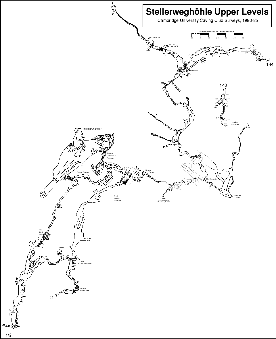
After the high entrances of 143 and 144 were explored, and the latter was connected into Stellerweg, and considerably more exploration was done in 142, including two connections into the main system, a lot more survey data was available, all of it above the Big Rift in Stellerweg. All these passages were drawn up, at a larger scale than the original published survey, and with the fridge north error corrected. However, this survey has never been published - CUCC stopped working in the cave and the project petered out.
A significant part of the survey (all of 142 and the passages of 41 from the entrance to the Big Pitch) is drawn up in machine-readable form, and extracts from this appear in these pages in the descriptions of the 1623/142 and 1623/144 entrances. An overview of the whole survey (at a reduced scale) is also on the site here. A lot more survey work is expected in the cave over the next few years (and this has already started). One connection from Schwabenschacht (1623/78) to the 1623/142 entrance has already been made, and other connections seem likely. It is hoped that we will also be able to obtain details of the other caves connected to the system, and be able to draw up a full survey of what is already at least a 20km system.