Surveys and Rigging Guides
sketches in
Logbook 2018-07-24b
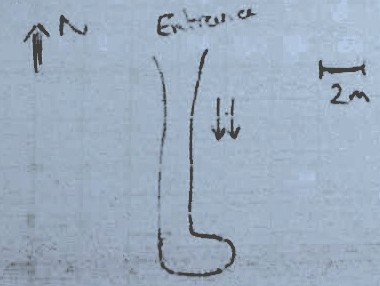
Underground Description
10m horizontal rift. dripping with 90° 'L'-bend 7m in, then dead end after a further 2.5m. Stoopy loose ceiling.
Photos on Philips camera. GPS on Philip's phone.. Waypoint in prospecting GPX file. Photos uploaded to expofiles/photos/PhilipWithnall.
Explorers
Discovered 2018 Phil W and Typhon
References
2018#17 - scanned diagrams and notes
Notes
{ After discussion with Elaine, the german name for this cave is Verliessmeinenkompassbeideranderenhöhle (VMKBAH) höhle. Note the duplicated höhle is necessary. Waypoint in prospecting GPX file. Photos uploaded to expofiles/photos/PhilipWithnall. }
.jpg)