Surveys and Rigging Guides
1990 plan Cambridge Underground 1991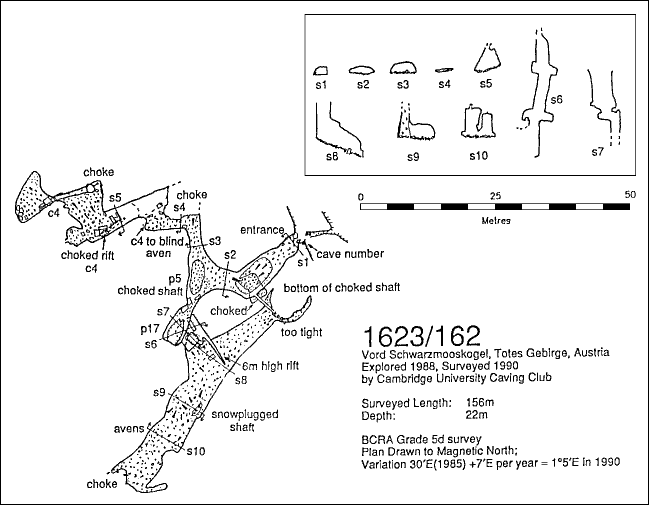
Underground Description
The cave takes a good couple of hours to explore thoroughly. Through the entrance is a large chamber with a 4m x 8m crater in it. A 3m climb down to the bottom gives access to a 3m climb back up to the right, leading into the cave and a crawl at the lowest point of the boulders leading into a choked bit of cave with small solutional stuff in the roof. It is also possible to traverse around the left edge of the crater to reach a triangular crawl which goes for about 10m before it gets too tight.The entire floor of this cave consists of small rocks and boulders. There is no solid rock anywhere horizontal, except halfway down the pitch.
After climbing out of the hole there is another 5m deep choked hole beyond. Traverses round to both the left and right are possible, although a little care is required due to the low roof and loose floor.
To the right, rubble coming out of the bottom of a choked shaft almost blocks the passage but a crawl through to the left remains, with a strong wind blasting through the confined space. Beyond this constriction the draught is lost. The roof remains low on the other side, although it is possible to stand up off to the left where there is a 4m climb up to what looks like a way on but is actually blind. Moving around the boulder pile to the right leads to a big passage. There are a few large boulders 10m to the right with a 4m climb down between them leading to a tight choked rift. This was also dug into from the top passage by the extremely zealous original explorers! There is an alcove in front and a rubble slope up to the right. Round the corner to the right is another shaft-bottom rubble pile and a hole disappearing into the roof. At the top of the slope to the left is a 4m climb up through and around big wedged boulders to reach an impressive chamber 7m × 9m and 12m high. There is a possible climb up into an aven in the corner which probably doesn't go and has a couple of moves at the top which need protecting.
Back at the fork near the entrance, turning left and thrutching over a couple of rocks (another windy spot) leads to the head of a 17m pitch broken by a ledge 8m down. There is a bolt for a ladder hang on this ledge. Going off to the left allows a safe traverse past the pitch continuation to the bottom of a 6m high rift with some ice in it, slowly narrowing as it goes up.
At the foot of the pitch is what looks like an ancient phreatic remnant. It is about 40m long and 6m wide, and mostly full of rocks. To the left it is blocked at the end by the rubble coming out of the bottom of a big shaft. It is possible to work round the foot of this for about 3m to the left and 10m to the right.
Going the other way down the passage reveals a large snow column by the left hand wall. It is possible to climb up between the column and its containing shaft, presumably all the way to the surface, but no-one has managed it yet. Beyond this column the roof gets lower, apart from a couple of solutional avens and eventually a small shaft-bottom rock pile and a couple of small inlet tubes mark the end of the cave.
There is no extant description or survey of what Brian and Becka discovered in 1999 except that it was a shaft to around 50m of passage. This and the position of their entrance suggests that they had dropped into the lower part of 162, near the snow column from the original description.