1623 / 115
(40m)
Schnellzughöhle 6/t/S/W x

Surveys and Rigging Guides

CUCC's parts surveyed to Grade 5 but not all drawn up - see here

Underground Description

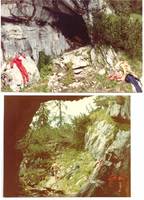
This is the main entrance through which the majority of the Stellerweghöhle system was explored. See the separate full guidebook description for details, just an overview is given here.


Photo July 2018, Philip Sargent.

The entrance leads to a non-obvious way on to the head of the short Bell Pitch, from where very awkward going leads out to a bigger passage to reach The Ramp a series of off-vertical pitches. The damper but technically easier Inlet Pitches drop to a Big Chamber, from where Pete's Purgatory starts, and leads in 800m of tortuous going to The Confluence and the larger streamway leading to the deepest point.

Better is the Purgatory Bypass which starts as dry fossil tubes, with a choice of routes to reach Junction Chamber where the Big Rift of Stellerweghöhle enters. Opposite, the huge fossil tube of Dartford Tunnel makes for easy progress to the Confluence, about halfway down the system. The continuing main streamway is interrupted by a bypassable sump and numerous pitches before a low airspace duck at the end of an unpromising canal leads to the spectacular Orgasm Chasm. Careful rigging avoids the water in this 140m shaft, ending in muddy passage and another short drop to a deep and terminal sump.

Photos from 1983

Explorers

CUCC 1980-1985

Wallets: scanned survey notes

There are 1 wallets with data for this cave:
1983#02

Notes

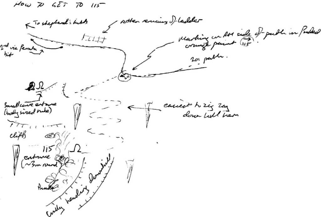
The Austrian Kataster has adopted a very perverse way of numbering things. Their numbers are as follows:

Entrances

  1. Id letter: '' Edit this entrance
    Marking
    Paint
    Marking Comment
    number painted on right (east-facing) wall of entrance
    Findability
    Coordinates
    Location
    'other' station no longer valid 1623.gps00.115
    Approach
    2018 Description: logbook 2018-07-18
    go along Stoger Weg past Windloch (32) and further past the next cave (marked 88 in faded red paint) in LHS of path. Go [10m] further from there along Stoger Weg and leave path descending limestone karren down to right. Proceed back along foot of karren slope and push aside 3-4 branches of bunde to reach a "path".
    Follow along this 'trod' until you can descend steeply to the left (a few more branches of bunde) to steep "rockery" scramble bank. Make your way with care down this and you should be able to see a truncated pine tree [4m high] on the other side of a small gully. (When seen from the other side, this pine tree has branches in the shape of a figure "4".) Descend and traverse round to the right and climb up to this pine tree across the gully.
    Now follow "path" down and to the right across 2 areas of soil/grass/loose stones to eventually reach a big pine tree with a bend in the trunk at ground level and a small cairn on the bend in the trunk. Continue down right through bunde with a little climb until you can see a large dead twisted tree root across a gully. Descend and get to this via via lush grass and flowers on steep slope and loose soil.
    At the twisted dead tree root there is an obvious route leading to the right. At this point you are only 13m from p115x but you can't see it as it faces S. and you are approaching from the N. 10m on you pass a large anthill and then 3m further and you're there.

    2007 Description. Good sketch of how to find it in Logbook Wed 11 Jul 2007 when Mark Doherty and Anthony Day found it (again) while looking for 115. 114 is the "Small Cave Entrance (body-sized tube)". Inserted here too:

    1983 description: Follow Stögerweg beyond Windloch to a steep descent. Just below this, by a large tree [now believed to have vanished in 2018] on the right of the path (permanent survey station P3), descend steeply to the right on a barely discernible trod.

    This involves at least one freeclimb which is awkward with lots of kit. Make lots of noise if you are first, especially on the first trip, since snakes seem to like it here. Eventually a large horizontal railway-tunnel-like entrance appears. If you fall off a cliff, you've gone a little too far downhill.

    Tag Location
    1623.p115x 47.66697N 13.80984E (UTM33 410650, 5279972), 1485m (SRTM is +66 m, distance from reference: 22m)

New Entrance

Survex File(s)

All survexfiles for this cave (if any)
Primary survex file for this cave
Download .3d file 1623-115.3d
cave survex path '1623/115/'