Entrances
-
Id letter: ''
197
Edit this entrance
- Marking
- Tag
- Marking Comment
- Number "B8" of 1976 vintage painted in dull green on the wall facing south, opposite the fault scarp, which is very hard to spot, although not fading appreciably year to year. There is an easier-to-find number painted higher up on an east-facing rock, initially in orange, but "refreshed" in red in 1995 as the orange paint was crap. Below this number is the drilled spit with tag "CUCC 1976 B8" which is also the point surveyed to. This will, in due course, be replaced by a new tag with the Austrian kataster number, on the same bolt.
Retagged 1997.
- Findability
- Coordinates
- Approach
- This is situated on the plateau just on a major fault where one climbs down over bare rock for 4m. From Top Camp, head somewhat east of north onto a large area of bare karren containing B11 (1623/198). Continue parallel with the line of a small scarp running north, and pass 1623/164 on the left. Scrambling past a wide snow choked shaft (1623/189) on the right, descend and turn right, along the line of a north-facing scarp containing B9 (1623/190), heading roughly east, and clamber down a few small scars to the large open doline.
- Photo(s)
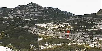
Photomontage showing location of B8 below scar. Vorderer Schwarzmooskogel and Schwarzmoossattel behind (Warning - full size image is 1000 pixels wide)
- Tag Location
- 1623.t197 47.68055N 13.80677E (UTM33 410443, 5281485), 1639m (SRTM is +51 m, distance from reference: 13m)
- Bearings
- (1976) Bräuning Nase 208°, Schönberg 350°, Spot point 1828, 240°
In fact it is impossible to see any landmarks from the actual entrance.
- Other Station
- 1623.gps00.b8 - post selective availability GPS 47.6806691N 13.8067982E (UTM33 410445, 5281499), 1655m (SRTM is +35m, distance from reference: 7m)