Entrances
-
Id letter: ''
100
Edit this entrance
- Marking
- Tag
- Marking Comment
- red painted number, with 1998 tag "1623 100 CUCC 1977" in centre (M6 stud).
This cave was originally only numbered in carbide, so was unmarked for years. It was relocated in 1989, but was not numbered until 1993 since AERW didn't think to carry paint while trying to find old holes. The orange number was fading and chipped in 1995, so was refreshed in red. The surface survey was to the centre of the middle digit of the number.
- Findability
- Coordinates
- Location
- Just beyond the col, on the left. It is, in fact, extremely near Top Camp, virtually on one of the routes to the Schwarzmooskogel areas.
- Photo(s)
-
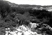
Nick Thorne and Simon farrow at 100 (1977) (Photos © Olly Betts 2005, Andy Waddington 1977)
- Tag Location
- 1623.p100 47.67931N 13.80574E (UTM33 410364, 5281348), 1640m (SRTM is +61 m, distance from reference: 22m)